জগদ্দল বিহার
Type: প্রত্নতাত্ত্বিক এলাকা
Contributed By: Nayeem ,Lonely Traveler


Brief
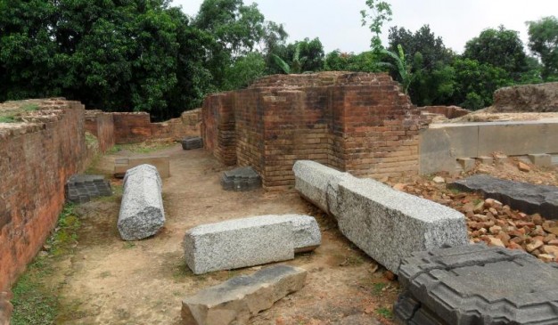
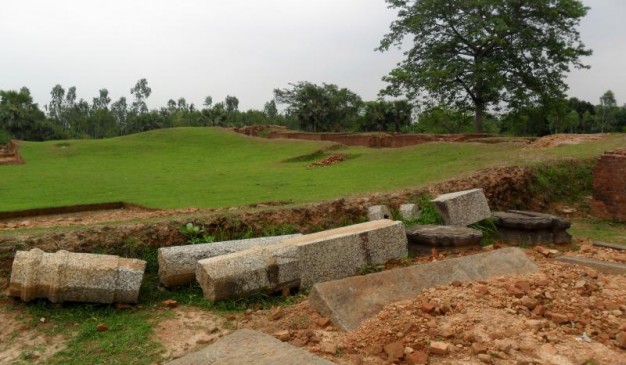
জগদ্দল বিহার নওগাঁ জেলা সদর থেকে প্রায় ৫৫ কিলোমিটার দূরে অবস্থিত একটি প্রাচীন স্থান। স্থানীয়রা এটিকে বটকৃষ্ণ জমিদার বাড়িও বলে থাকে এবং জায়গাটিকে জজ্ঞদল হিসেবেও বলা হয়ে থাকে। বর্তমান উত্তরবঙ্গের বরেন্দ্রতে (১১শ শতাব্দীর শেষ থেকে ১২শ শতাব্দীর মধ্যে) এটি ছিল একটি বৌদ্ধ বিহার এবং শিক্ষাদান কেন্দ্র। পাল রাজবংশের রাজা সম্ভবত রামপাল (১০৭৭-১১২০) পাল শাসনামলের শেষার্ধে এটি প্রতিষ্ঠা করেন উত্তরপশ্চিম বাংলাদেশে অবস্থিত ধামরিহাট উপজেলার জাগদাল গ্রামে যে জায়গাটি ভারত সীমান্তবর্তী এবং পাহাড়পুরের নিকটে অবস্থিত।
উত্তর-পূর্ব ভারতে পাল শাসনামলের চার শতকে (খ্রিস্টপূর্ব ৭৫৬-১১৭৪) প্রাচীন বাংলা এবং মাগাধাতে অনেক বিহার প্রতিষ্ঠা করা হয়। ধর্মপাল (৭৮১-৮২১) একাই ৫০টি বিহার প্রতিষ্ঠা করেন যার মধ্যে ছিল সে সময়ের প্রধান বিশ্ববিদ্যালয় বিক্রমশীলা। তিব্বতের সূত্র অনুযায়ী পাঁচটি শ্রেষ্ঠ মহাবিহার ছিলঃ বিক্রমশীলা ছিল সেই যুগের প্রধান বিশ্ববিদ্যালয়; নালান্দা; সোমপুর মহাবিহার; অদন্তপুর এবং জাজ্ঞাদলা। পাল আমলে পূর্ব ভারতে শিক্ষাদানকারী সবগুলো বৌদ্ধবিহার রাষ্ট্রের তত্ত্বাবধানে ছিল এবং বৌদ্ধবিহারগুলো একটি নেটওয়ার্ক তৈরি করেছিল এবং বিহারগুলোর মধ্যে সমন্বয় ছিল এতে করে মহান মনিষীদের জন্য বৌদ্ধবিহারগুলোর মধ্যে অবস্থান বদলানো সহজ হত।
বজ্রানা বৌদ্ধশাস্ত্রে বিশেষায়িত ছিল জগদ্দল। পরবর্তীকালে জানা যায় যে কানজুর এবং তেংজুরে উল্লেখিত প্রচুর অক্ষর এই জগদ্দলেই গঠন করা হয়েছিল। সম্ভবত সাংস্কত ভাষার প্রাচীনতম সংকলন সুভাসিতারত্নকোষ জগদ্দলেই ১১শ শতাব্দীর শেষের দিকে অথবা ১২শ শতাব্দীর শুরুতে গঠন করা হয়।
How to go
নওগাঁ পৌছানোর পর লোকাল বাসে চড়ে ধামড়িহাটে এই বিহার দেখে আসতে পারেন।
How To Reach: নওগাঁ জেলা
Buses can be used to get between major towns, or else rickshaws for small distances. There are two major Bus Stand/ Stop in Naogaon District. The First but small one is “Dhaka Bus Stand” , where usually you will get buses to go to Dhaka, Bogra, Sylhet and Chittagong mainly. The other one is “Baludangga Bus Stand” situated almost at the end of the Naogaon Municipality. At “Baludangga” Bus Stand, you can get buses to travel to Paharpur, and other Sub-division of Naogaon District, such Sapahar, Nazipur, badalgachi etc.
The other most convenient options is the “Bangladesh Railway”, from “Santahar” Railway Station. You can find numerous trains from “Santahar” to various district in Northern & Southern Bangladesh. Using First class ticket is a very convenient way for foreign Tourists, to be safe and pleasant journey, and price is also very reasonable in fact Bangladesh Railway is cheap.
SR Travels has regular routes from Dhaka to Naogaon: (Both AC and Non-AC are available). Counters of SR Travels in Dhaka:
1. Kollyanpur Bus Stand (Counter-1), phone: 02-8013793, 02-8019312,
01711-394801
2. Abdullahpur Bus Stand, Phone: 01711-944023
3. Gabtoli Bus Terminal, Phone: 02-8011226
4. Bijoy Nagar, Kakrail, Phone: 02-9352118
5. Mohakhali Bus Terminal, Phone: 02-8834833, 01552-315831
6. Kollyanpur Bus Stand (Counter-2), Phone: 02-8060876
Some bus services from Dhaka to Naogaon are:
1. Shayamoli Paribahan – TK 350-450
2. Hanif Enterprise – TK 350-450
3. Ekota Paribahan – TK 350-450
There are plenty more services almost similar, but air conditioned services give a little deluxe flavor.
There are a number of luxurious intercity services between Dhaka and Naogaon each day. Railway station in Naogoan is “Santahar Junction”, which is situated at the end of Bogra. However it costs just TK 15-20 to reach Naogaon by rickshaw or CNG-powered auto rickshaw.
From Dhaka to Santahar, Naogaon Intercity trains from BimanBandar: Except “Nilsagar” all the train can be embarked on from “Kamlapur Junction Station, Dhaka” as well. Just add around 35-40 mins prior to the time given for Bimanbandor (Bengali of Airport) time.
Train No Name Off Day From Departure To Arrival
772 Rangpur Express Monday Airport 5:58 AM Dhaka 6:35:00 AM
771 Rangpur Express Sunday Airport 9:33 AM Zamuna Bridge (East) 11:32 AM
705 Ekota Express Tuesday Airport 10:22 AM Dinajpur 7:10 PM
706 Ekota Express Monday Airport 6:43 AM Dhaka 7:40 AM
751 Lalmani Express Friday Airport 10:42 PM Lalmonirhat 8:20 AM
752 Lalmani Express Friday Airport 8:28 PM Dhaka 9:05 PM
757 Drutajan Express Wednesday Airport 8:12 PM Dinajpur 5:00 AM
758 Drutajan Express Wednesday Airport 5:10 PM Dhaka 5:55 PM
765 Nilsagar Monday Airport 8:36 AM Nilphamari 5:30 PM
766 Nilsagar Sunday Airport 7:35 AM Dhaka Cantt 7:45 AM
Note: All the train above touches “Santahar”, destination above are end destination of the train.
Where to Stay
1. Hotel Agomoni
Address: Muktir Mor, Naogaon.
Manager: Md. Salah Uddin Parvej,
Phone: 0741-63351
2. Hotel Obokas
Address: Par-Naogaon, Santahar Road, Naogaon.
Manager: Md. Abdul Azij Chowdhury,
Phone: 0741-62356
3. Afsar Rest House
Sadar Hospital Road, Naogaon.
Manager: Md. Khayrul Alam Advocate,
Phone: 0741-63153
4. Archaeological Rest House, Paharpur,
Phone: 0571 89119
Things to do
1. জমিদার বাড়ির অবশিষ্ট দেখতে পারেন।
2. দীঘির ছবি তুলতে পারেন পাশাপাশি তার সৌন্দর্যও উপভোগ করতে পারেন।
Eating Facilities
আশেপাশে রেস্টুরেন্ট অথবা ফাস্ট ফুডের দোকান খুঁজতে পারেন। অথবা সাথে করে খাবার নিয়েও যেতে পারেন। অথবা নওগাতে কোথায় খাবেন জানতে এখানে ক্লিক করুন


