Array
(
[0] => Array
(
[name] => Kusumba Mosque
[post_id] => 3656
[post_link] => http://offroadbangladesh.com/bn/places/kusumba-mosque/
[thumb_link] => http://offroadbangladesh.com/wp-content/uploads/2015/02/84463426-300x199.jpg
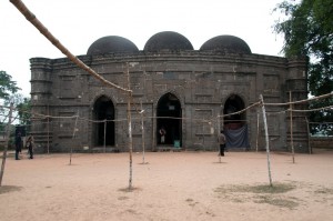
[post_content] => Kusumba Mosque is named after the village of Kusumba, under the Manda upazila of Naogaon district, on the west bank of the Atrai River. It is inside a walled enclosure with a monumental gateway that has standing spaces for guards. It was built during the period of Afghan rule in Bengal under one of the last Suri rulers Ghiyasuddin Bahadur Shah, by one Suleiman who was probably a high ranking official. The inscription tablet in Arabic (only the word ‘built by’ is in Persian) dating the building to 966 AH (1558-59 AD) is fixed over its eastern central entrance.
Although built during Suri rule, it is not influenced at all by the earlier Suri architecture of North India, and is well grounded in the Bengal style. The brick building, gently curved cornice, and the engaged octagonal corner towers are typical features. The mosque, presently protected by the Department of Archaeology of Bangladesh, was badly damaged during the earthquake of 1897. Although the main fabric of the building is of brick the entire exterior walls, and the interior up to the arches of the pendentives have stone facing. The columns, platform, floor, and perforated side screens are of stone. The mosque has a rectangular plan with three bays and two aisles, three entrances on the east and two each on the north and south sides.
The central mihrab is projected in the west. The interior west (qibla) wall has two mihrabs on the floor level opposite the central and southeastern entrances, but the one in the northwestern bay is above a raised platform ascended by a staircase on the east. The presence of such a platform in a non-imperial mosque indicates that not only royalty, but nobility and high-ranking officials were also separated from the general public during prayers. The mihrabs have elaborate stone carving. They have cusped arches crowned with kalasa (water pot) motifs, supported on intricately carved stone pillars which have projections and tasseled decorations hanging from chains. Bunches of grapes and vines curve in an almost serpentine manner on the mihrab frames, and kalasas, tendrils and rosettes are reduced to dots.
The platform edge has grape vine decoration, and there are rosettes on the spandrels of the arches supporting the platform, as well as on the mihrab wall. The stone used in the exterior facing is of a coarse quality and carved in shallow relief. Mouldings are most prominent decorative feature on the outside. They divide the walls into upper and lower sections, run all along the curved cornice, around the corner towers, in a straight line below the cornice, and frame the rectangular panels in the east, south and north walls. The spandrels of the central entrance arch are filled with small kalasa and rosette motifs. The north and south sides have screened windows.
)
[1] => Array
(
[name] => {:en}Megalithic Tombs Stone{:}{:bn}প্রাগৈতিহাসিক যুগের স্মৃতিস্তম্ভ{:}
[post_id] => 4276
[post_link] => http://offroadbangladesh.com/bn/places/megalithic-tombs-stone/
[thumb_link] => http://offroadbangladesh.com/wp-content/uploads/2015/03/Jaintapur-Meghalithic-Tombs-stone2-300x225.jpg
[post_content] => {:en}
This glorious place, of Megalithic Tombs Stone, holds the remaining pieces of Jainta Kingdom. The damaged Rajbari or King's palace, Jainteshvari temple, and megalithic monument are found here. Megalithic monument is the best heritage structure among these. There is no other megalithic monument in Bangladesh other than this. Jaintiapur is the only place in Bangladesh where Meghalithic remnants have been discovered.
Due to its geophysical condition the region remained independent for a long time and was well known as Jaintapur Kingdom. As such it was mentioned in Epic, Puranic, and Tantric literatures. However, a number of local legends, folk tales, and inscriptions suggest that from approximately the 7th/8th century AD Jaintapur came under the control of Kamarupa Kingdom and that later it went under the control of the Chandra and Varman rulers.
After the fall of the Varmans, Jaintapur was again ruled for some time by the Deva dynasty. Jayanta Ray, the last ruler of the Deva dynasty, had a daughter named Jayanti, who got married to a son of a Khasi chief, named Landowar. Due to this matrimonial alliance, Jaintapur kingdom went under the control of the Khasis in c 1500 AD. Subsequently, Khasi kings ruled over the kingdom independently till the British occupied it in 1835.
{:}{:bn}স্মৃতিস্তম্ভটি সিলেট সদর থেকে ২৫ মাইল দূরে ভারতের মেঘালয়ের নিকটে এই প্রাগৈতিহাসিক যুগের স্মৃতিস্তম্ভ অবস্থিত। এ স্থানে রয়েছে জৈন্তা সাম্রাজ্যের অবশিষ্ট স্মৃতি। এখানে আপনি ক্ষতিগ্রস্ত রাজবাড়ি, জৈন্তেসবাড়ি মন্দির, এবং সবচেয়ে আকর্ষণীয় প্রাগৈতিহাসিক যুগের স্মৃতিস্তম্ভ দেখতে পাবেন। জৈন্তাপুর ব্যাতিত বাংলাদেশের আর কোথাও প্রাগৈতিহাসিক যুগের স্মৃতিস্তম্ভ পাওয়া যায়নি।{:}
)
[2] => Array
(
[name] => Devi Chowdhurani Zamindar Bari
[post_id] => 1895
[post_link] => http://offroadbangladesh.com/bn/places/devi-chowdhurani-zamindar-bari/
[thumb_link] => http://offroadbangladesh.com/wp-content/uploads/2015/02/Devi-Chowdhuranir-Zamider-Bari-300x190-300x190.jpg
[post_content] =>
The lanlord of pirgacha sub district norendronarayan son of raghabendranarayan died in 1765 without any legacy. Then the wife landowner Joydurga manage the landlord for three decades. This Joydurga is popularly known as Devi Chowdhurani in history.In the time of Sonnasi Bidroho (Sannasi revolution) she keep peace with VobaniPathok and war against English. In this insurgency collector Richard Gudland and army commander lieutenantbrenan got feared and forfeit the landlord of DeviChowdhurani. This time Devi Chowdhurany Levant herself for some days. After that time she again came to manage the landlord and she manage it for 1791. Now all of the building of it damaged. Only the pond is also now there.
)
[3] => Array
(
[name] => Telia Hindu Moth
[post_id] => 5853
[post_link] => http://offroadbangladesh.com/bn/places/telia-hindu-moth-%e0%a6%a4%e0%a7%87%e0%a6%b2%e0%a6%bf%e0%a7%9f%e0%a6%be-%e0%a6%b9%e0%a6%bf%e0%a6%a8%e0%a7%8d%e0%a6%a6%e0%a7%81-%e0%a6%ae%e0%a6%a0/
[thumb_link] => http://offroadbangladesh.com/wp-content/uploads/2015/03/DSC_03011-199x300.jpg
[post_content] =>
Telia Hindu Moth (তেলিয়া হিন্দু মঠ) is a sacred place for Hindu religious people in Shibpur Upazila,Narsingdi. It is one of the common religious structures in Bangladesh. It was built in 20th century. In several cases, this kind of structures is a complex with the crematorium.Likewise,there is a Crematorium along with the monastery or moth (মঠ). It’s a complex of two brick made structures situated in very short distance. It’s situated just beside the river Hariabhanga (Branch of Old Brahmanputra). All around of this Monastery is very calm & quiet. So far eye goes, you can just observe a vast cultivable land.
Architectural property and layout:
The Architectural property of this monastery is very simple and regular like the others moth in Bangladesh. It’s has grown narrower from bottom to top by three steps. The inner part of this monastery is hollow. From bottom, the second step of this structure contains arch shaped door which are originally a closed design. In the upper portion of these door design are decorated with different kinds of flower & leafs motives. On the top most of this monastery there is a iron three head which symbolizes the icon of Hindu Religion.
If heading to the Village Putia, this feature is situated in left side of the road and crematorium is in right side.
)
)