Brief
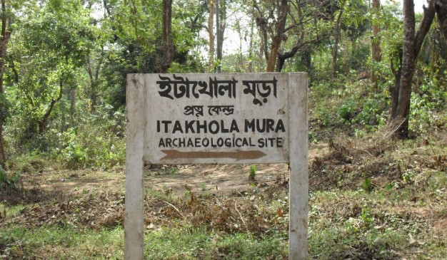
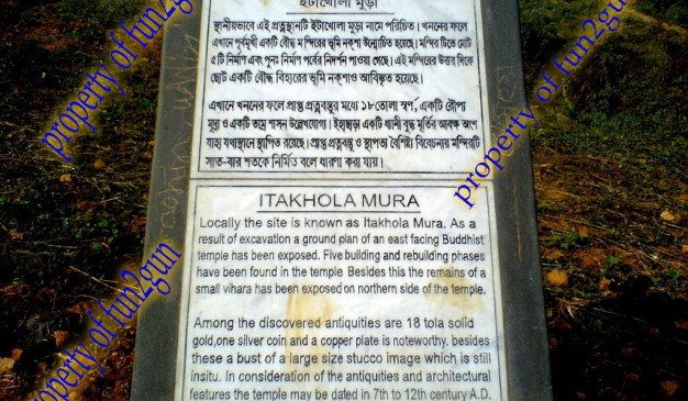
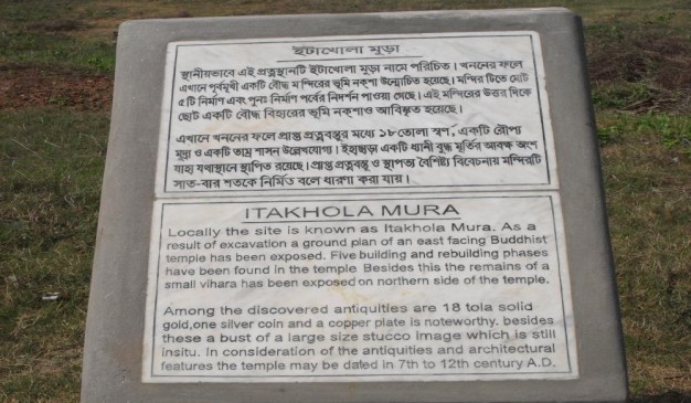
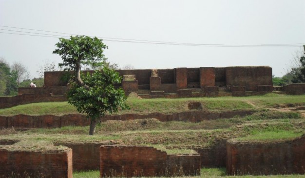
Itakhola Mura is an archaeological site in Mainamati. This site is one of the most impressive ruins. It lies in three terraces on adjacent hillocks just opposite the Rupban Mura site across the Kotbari road in Comilla. Excavations have revealed here a grand stupa complex with an attached monastery, located 42m to its north. The cultural phases of the site are stated (or overstated) to be five; the earlier three being still buried underneath the later remains.
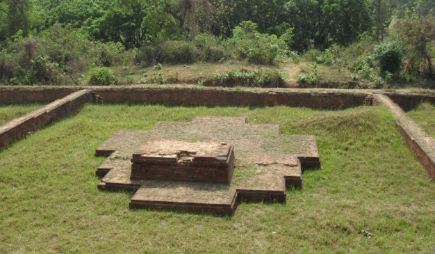
The Stupa Complex was originally built as a solid stupa in the traditional style on a 13.1 meter square basement. However, it has one peculiarity; a small sanctum (2.4 m x 2.1 m) built in the center of its eastern or front side.
Subsequently, the shrine was enlarged and elaborated by additions and alterations, especially by adding three long narrow chapels in the eastern side after blocking the old sanctum; thus giving the structure an oblong shape (41.4 m x 24m). In this particular feature, it is strikingly similar to the Rupban Mura shrine. The side chapels were ultimately blocked up, leaving space for a few cubicles for installing cult images, as in other parts of the shrine. This establishment is surrounded by a 2.6 m wide circumlocutory passage and is enclosed by a 1.2 m thick boundary wall.
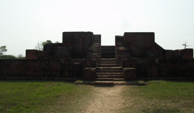
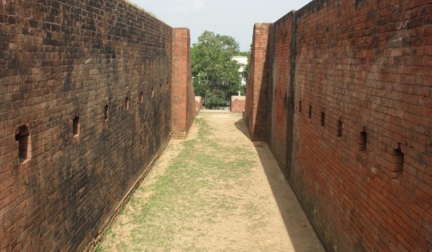
This holy precinct is again enclosed within a much larger, well-defined, and better preserved boundary wall (79 m x 56 m), in the slightly lower second terrace. It contains three interesting subsidiary shrines, two in two corners of the eastern side, and the other, a slightly larger one, at the back in the west. An elaborate entrance with 22 broad steps at the Center of the eastern side leads to the much lower third terrace. The outer face of its damaged boundary wall in this front side is excellently decorated with offsets, sunken panels, and ornamental designs.
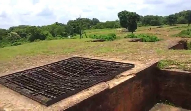
Five votive stupas lie at the base of the long staircase, three of them in a north south row within a well-defined enclosure, all semi-cruciform in shape, like that of the larger subsidiary shrines in the western side of the second terrace. They certainly represent an experimental early stage in the development of the cruciform style in Buddhist architecture that we see in mature form at shalvan vihara, paharpur, Vikramashila and many other sites. These structures may reasonably be dated as belonging to 7th-8th centuries AD.
The Monastery This medium sized monastery of the usual square shape with 19 cells and one entrance hall was built around an open courtyard, 16.2m. Square, on a separate mound. Its monumental gateway complex, 17.6m x 8.5m, projecting outwards, lies at the Centre of the eastern wing. Some of the cells have brick-built bedsteads. This structure was badly damaged by brick-hunters in 1944-45.
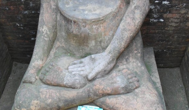
Mentionable antiquities from the site, besides the stucco image, are three round pellets of solid gold, (19 tolas), and a copperplate inscription, discovered during clearance work after the excavations. The copperplate has not yet been deciphered.
Array
(
[0] => Array
(
[name] => Ulpur Zamindar Bari
[post_id] => 18413
[post_link] => http://offroadbangladesh.com/bn/places/ulpur-zamindar-bari/
[thumb_link] => http://offroadbangladesh.com/wp-content/uploads/2015/09/Ulpur-Jomidarbari-1-300x169.jpg
[post_content] =>
During 1850, the greater Gopalganj area was ruled by the Zamindar. At that time, they made hundreds of buildings for their residence and official purposes. The buildings were made in the traditional Zamindar Bari look and style. In the last 150 years, most of the houses were destroyed by erosion. After being taken by the government, the authority turned some of these houses into government buildings. Now, most of the houses are abandoned or occupied by local people.
There is a cluster of old buildings in the Ulpur Area which is situated in the Gopalgonj - Takerhat highway, not so far from the Gopalgonj main town. As soon as you cross the Ulpur bridge from Ulpur bazar, the buildings start to appear. The first one was used as the Union Land Office (Government) but is now abandoned. The local people over there are now using it to stock fodder.
The second was probably used as a duplex residential complex but now is being used as the Sub Post Office. The surrounding environment is good and the building is covered by bamboo stocks. In the main road, there is a large old building, which was probably the main building. Outside this building the words "Dinesh Dham" in Bengali is carved in a white slate. This building is currently occupied by some local inhabitants.
If we go farther, then we will see another broken house formerly used as the Upazilla Registry office, now almost completely in ruins. "Din-Dham" in Bengali is also carved outside he building in white stone.
The overall environment of this village is very good and peaceful. Walking for an hour in the silence of this area will be relaxing. The most attractive structure is the Temple. The walls of the temple is decorated with colorful glass & ceramics. The temple looks good but it is also abandoned so the temple has shifted into a newly constructed building.
)
[1] => Array
(
[name] => Govinda Vita at Mahasthangarh
[post_id] => 6557
[post_link] => http://offroadbangladesh.com/bn/places/govinda-vita-at-mahasthangarh/
[thumb_link] => http://offroadbangladesh.com/wp-content/uploads/2015/04/Govinda-Vita2-300x240.jpg
[post_content] =>
Govinda Vita at Mahasthangarh is another archaeological spot from the great Mahasthangarh of Bogra. This is also at Shibganj, and just opposite of the Mahastangarh Museum. This one is also close at Sunday, and open for other days from 9:00 to 5:00. During summer time, the closing time extends for one hour.
This is situated just beside the famous river Korotoa of Bogra. Once upon a time it was a giant river, but day by day it’s becoming so narrow that you may feel it’s a canal.
From the excavation, some important antiquities discovered at Govinda Bhita that includes cast copper coins, silver coins, NBP wares, terracotta female figurines with sunga affinities, terracotta seal bearing Brahmi script and semi-precious stone beads.
[This spot needs more detail. If you have more information and photos, please be advised to add in our website. Your name will be published as a Content Contributor]
)
[2] => Array
(
[name] => {:en}Pailgaon Zamindar Bari{:}{:bn}পাইলগাঁও জমিদারবাড়ী{:}
[post_id] => 22961
[post_link] => http://offroadbangladesh.com/bn/places/pailgaon-zamindar-bari/
[thumb_link] => http://offroadbangladesh.com/wp-content/uploads/2015/11/P_20151014_130750_1_p-300x169.jpg
[post_content] => {:en}
Pailgaon Zamindar Bari is one of the remarkable old structures of Jagannathpur in Sunamganj. This 300 years old palace was established on 5.5 acres of land.
The last person of this Zamindar family was Brajendra Narayan Chowdhury. He was a famous politician at that time and a member of the congress of Sylhet too at that time.
The place is situated near the bank of Kushiara river in Sunamganj District. It is at Pailgaon Union under Jagannathpur Upazila.
History of this place: Thousand years ago, decedents of Pal Dynasty lived here. As time goes, "Das" family took their place. Pir Mohammad Badsha (Muslim Rulers) gave them the title - "Chowdhury". Ram and Sreeram were two descendants of this bloodline. One of their descendants Madhab Ram gained much popularity in his locality at that time. He did a lot of social welfare.
Their descendants Brojnath had two sons. Their named were Roshomoy Chowdhury and Sukhumoy Chowdhury. The place is locally known by the name after of Zamindar Roshomoy Chowdhury. The last ruler of the family was famous Brajendra Narayan Chowdhury.
{:}{:bn}প্রাচীন পুরাকীর্তির অন্যতম নিদর্শন সুনামগঞ্জের জগন্নাথপুর উপজেলার পাইলগাঁও জমিদারবাড়ী। প্রায় সাড়ে ৫ একর ভূমির ওপর প্রতিষ্ঠিত তিন শত বছরেরও বেশী পুরানো এ জমিদার বাড়ীটি এ অঞ্চলের ইতিহাস-ঐতিহ্যের নিদর্শন ।এ জমিদার পরিবারের শেষ জমিদার ব্রজেন্দ্র নারায়ণ চৌধু রী ছিলেন প্র খ্যাত শিক্ষাবিদ ও রাজনীতিবিদ। তিনি ছিলেন সিলেট বিভাগের কংগ্রেস সভাপতি এবং আসাম আইন পরিষদের সদস্য। সিলেট বিভাগের সুনামগঞ্জ জেলায় জগন্নাথপুর উপজেলার অধীন ৯ নম্বার পাইলগাও ইউনিয়নের পাইলগাও গ্রামে ঐতিহ্যবাহি এ জমিদারীর অবস্থান। জমিদার বাড়ী দক্ষিণ দিকে সিলেটের কুশিয়ারা নদী বহমান। প্রখ্যাত ঐতিহাসিক অচ্যূতচরণ চৌধুরী পাইলগাও জমিদার বংশের রসময় বা রাসমোহন চৌধুরী হতে প্রাপ্ত সূত্রেলিখেছেন যে; পাইলগাওয়ে বহুপূর্বকালে পাল বংশীয় লোক বসবাস করত। এ গোষ্টিয় পদ্মলোচন নামক ব্যক্তির এক কন্যার নাম ছিল রোহিণী। কোন এক কারণে রাঢ দেশের মঙ্গলকোট হতে আগত গৌতম গোত্রীয় কানাইলাল ধর রোহিণীকে বিবাহ করত গৃহ-জামাতা হয়ে এখানেই বসবাস শুরুকরেন। কানাইলাল ধরের আট পুরুষ পরে বালক দাস নামের এক ব্যক্তির উদ্ভব হয়। এ বালক দাস থেকে এ বংশ বিস্তৃত হয়। বালক দাসের কয়েক পুরুষ পর উমানন্দ ধর ওরফে বিনোদ রায় দিল-ীর মোহাম্মদ শাহ বাদশা কর্তৃ ক চৌধুরী সনদ প্রাপ্তহন। বিনোদ রায়ের মাধব রাম ও শ্রীরাম নামে দুই পুত্রের জন্মহয়। তার মধ্যেমাধব রামজনহিতকর কর্মপালনে নিজ গ্রাম পাইলগাঁও এ এক বিরাট দীঘি খনন করে সুনাম অর্জন করেন। তার দেয়া উক্তদীঘি আজও ঐ অঞ্চলে মাধব রামের তালাব হিসেবে পরিচিতহচ্ছে। মাধব রামের দুই পুত্র মদনরাম ও মোহনরাম । উক্ত মোহনরামের ঘরে দুর্লভরাম, রামজীবন, হুলাসরাম ও যোগজীবন নামে চার পুত্রের জন্ম হয়। এই চার ভাই দশসনা বন্দোবস্তের সময় কিসমত আতুয়াজানের ১থেকে ৪ নং তালুকের যতাক্রমে বন্দোবস্তগ্রহন করে তালুকদার নাম ধারণ করে। এদের মধ্যে হুলাসরাম বানিয়াচং রাজ্যের দেওয়ানি কার্যালয়ে উচ্চ পদের কর্মচারীনিযুক্ত হন। হুলাসরাম চৌধুরী বানিয়াচং রাজ্যের রাজা দেওযান উমেদ রাজারঅনুগ্রহে আতুয়াজান পরগণায় কিছু ভূমি দান প্রাপ্তহন। হুলাসরামের প্রাপ্তভূমির কিছু কিছু চাষযোগ্যও কিছু ভূমি চাষ অযোগ্যছিল। পরবর্তিতে হুলাসরাম চাষ অযোগ্য ভূমিগুলোকে চাষযোগ্যকরে তুললে এগুলোই এক বিরাট জমিদারীতে পরিণত হয়ে উঠে। হুলাস রামের ভাতুষ্পুত্রবিজয়নারায়ণের একমাত্রপুত্রব্র জনাথ চৌধুরীজমিদারি বর্ধিত করে এক প্রভাবশালী জমিদারে পরিণত হন। ব্রজনাথ চৌধুরীর দুইপুত্ররসময় ও সুখময় চৌধুরী। রসময় চৌধুরীর পুত্র ব্রজেন্দ্রনারায়নই ছিলেন এবংশের শেষ জমিদার।{:}
)
[3] => Array
(
[name] => Ghoshal Bari Zamindar Palace
[post_id] => 11775
[post_link] => http://offroadbangladesh.com/bn/places/ghoshal-bari-zamindar-palace/
[thumb_link] => http://offroadbangladesh.com/wp-content/uploads/2015/07/IMG_20150527_135541718-300x169.jpg
[post_content] =>
Ghoshal Bari Zamindar Palace, About 150 years old (now rebuilt) zamindar bari is located just nearby the Radha-Krisna temple with its outstanding view at Khilpara, South Betka village, Tongibari Upazila, Munshiganj District.
[This spot needs more information. If you have information, please be advised to add in our website. Your name will be published as a Content Contributor]
)
)