Where to Stay
1. Hotel Raffell Inn
Gowalchamot (গোয়ালচামট), Faridpur
32 rooms, Non-governmental,
Phone: 0631-61106
2. Hotel Laxury, Resident
Gowalchamot (গোয়ালচামট), Faridpur
65 rooms, Non-governmental,
Phone: 0631-62623
3. Hotel Padma, Resident
Mujib Road, Faridpur
45 rooms, Non-governmental,
Phone: 0631-62685
4. Hotel Park Palace, Resident
38 rooms, Non-governmental,
Phone: 01556327067
5. Hotel Shyamoli, Resident
Mujib Road, Faridpur
13 rooms, Non-governmental,
Phone: 0631-64538
6. Hotel jonaki, Resident
Gowalchamot (গোয়ালচামট), Faridpur
44 rooms, Non-governmental,
Phone: 0631-64168
7. Regional Rice Research Institute, Guest House
Chief Scientific Officer, Regional Rice Research Institute,
Vanga (ভাঙ্গা), Faridpur
Governmental, 100/- for Non-AC
Phone: 06323-56329
8. সুকন্যা ভবন
Address: Faridpur District
9. Jui House
Faridpur – Magura – Jhenaidah – Jessore – Khulna – Mongla Road
Array
(
[0] => Array
(
[name] => {:en}Jaflong{:}{:bn}জাফলং{:}
[post_id] => 4142
[post_link] => http://offroadbangladesh.com/bn/places/jaflong/
[thumb_link] => http://offroadbangladesh.com/wp-content/uploads/2015/03/800-Jaflong_Sylhet_Shahnoor-Habib-Munmun1-300x225.jpg
[post_content] => {:en}
Jaflong is a union situated at Bangladesh-India border. Jaflong is a landscape beauty among gardens and hills. It is situated next to the river Peain round Hill Khashia. The Mari River originating from the great Himalayas brings tons of stone slabs with its stream. It’s a hilly area comprising of green forests.
Jaflong is a hill station and popular tourist destination in the Division of Sylhet, Bangladesh. It is located in Gowainghat Upazila of Sylhet District and situated at the border between Bangladesh and the Indian state of Meghalaya, overshadowed by subtropical mountains and rainforests. Jaflong is famous for its stone collections and is home of the Khasi (also known as Khasia) tribe.
Jaflong is one of the most attractive tourist spots in Sylhet division. It is about 60 km from Sylhet town and takes two hours drive to reach there. Jaflong is also a scenic spot nearby amidst tea gardens and rare beauty of rolling stones from hills. It is situated besides the river Mari in the lap of Hill Khashia.
{:}{:bn}
বাংলাদেশ-ভারতের সীমান্তবর্তী খাসিয়া পাহাড়ের কোলে মারি নদীর পাশে অবস্থিত পাহাড়, সবুজ বন ও বাগানের সৌন্দর্য ঘেরা একটি পাহাড়ি অঞ্চলের নাম জাফলং। হিমালয় থেকে সৃষ্ট মারি নদী এখানে প্রচুর পরিমানে পাথরখণ্ড বয়ে নিয়ে আসে।
জাফলং হল সিলেট বিভাগের একটি হিল স্টেশন এবং অন্যতম আকর্ষণীয় পর্যটন কেন্দ্র। সিলেট শহর থেকে ৬০ কিলোমিটার দূরে অবস্থিত এই পর্যটন কেন্দ্রে সড়কপথে পৌছাতে প্রায় দুই ঘণ্টা সময় লাগে। পাথর সংগ্রহ করা এবং আদিবাসী খাসিয়া সম্প্রদায়ের বসবাস এই দুটি কারনে জাফলং এর খ্যাতি রয়েছে। চা বাগান এবং পাহাড় থেকে গড়িয়ে আসা পাথরের বিরল সৌন্দর্যের দেখা মিলবে এখানে।
{:}
)
[1] => Array
(
[name] => {:en}Kongsha Nodi{:}{:bn}কংস নদী{:}
[post_id] => 5192
[post_link] => http://offroadbangladesh.com/bn/places/kongsha-nodi/
[thumb_link] => http://offroadbangladesh.com/wp-content/uploads/2015/03/Kongsho-nodi-Arif-Hasan1-300x225.jpg
[post_content] => {:en}
Kangsha (কংস), a river from Bangladesh (বাংলাদেশ). It has several names, Kangsha (কংস), Kangshai (কংসাই), Kangshabati (কংসবতী), etc. This flows through Mymensingh (ময়মনসিংহ) and Netrakona (নেত্রকোনা). All of the photos of this river were taken from Netrakona (নেত্রকোনা).
The river is originated from the Garo Hills (গারো পাহাড়) of India and flows as Kongsho (কংস), and later joined with the Shomeswari (সোমেশ্বরী) river at Jaria-Jhanjail (জারিয়া-ঝান্জাইল). The river kept the name Kangsha (কংস) after joining together.
Near the bridge you'll find two bazaar at either side. One is Jaria (জারিয়া), and other one is Jhanjail (ঝান্জাইল). People used to call this place as Jaria-Jhanjail (জারিয়া-ঝান্জাইল) together.
During its course the river become too narrow and before demising it has joined with another great river of Bangladesh, Shurma (সুরমা), at Sunamganj (সুনামগঞ্জ).
All the photos of this article were taken from the car while crossing the Kongsho Bridge at Jaria-Jhanjail. GPS coordinate of the bridge at (25° 0'46.59"N, 90°38'50.00"E)
{:}{:bn}
বাংলাদেশের অন্যতম এই নদীটির বিভিন্ন নাম রয়েছে যেমনঃ কংস, কংসাই, কংসবতী ইত্যাদি। ময়মনসিংহ এবং নেত্রকোনা জেলার মধ্যে দিয়ে এই নদীটি বয়ে গিয়েছে। ভারতের গারো পাহাড় থেকে উৎপত্তি হয়ে এই নদীটি কংস নামে বাংলাদেশে প্রবেশ করেছে এবং জারিয়াঝানজাইল নামক স্থানে সোমেশ্বরী নদীর সাথে মিলিত হয়েছে। সোমেশ্বরী নদীর সাথে মিলিত হবার পর নদীটির নাম কংসই রয়েছে।
কংস সেতুর কাছে নদীর উভয় প্রান্তে দুটি বাজার রয়েছে। একটি বাজারের নাম জারিয়া এবং অপরটির নাম ঝানজাইল। স্থানীয়রা এই জায়গাটিকে জারিয়া ঝানজাইল নামে বলে আসছে। ধীরে ধীরে নদীটির চলার পথ সরু হয়ে এসেছে এবং সুনামগঞ্জে এই নদীটি বাংলাদেশের অন্যতম নদী সুরমার সাথে মিলিত হয়েছে।
জিপিএস এ কংস নদীর অবস্থান হল (২৫°০'৪৬.৫৯"উ, ৯০°৩৮'৫০.০০"পু)
{:}
)
[2] => Array
(
[name] => Gomti River
[post_id] => 7068
[post_link] => http://offroadbangladesh.com/bn/places/gomti-river/
[thumb_link] => http://offroadbangladesh.com/wp-content/uploads/2015/04/Gomti-River1-300x240.jpg
[post_content] =>
Comilla has two predominant rivers. One is Meghna River, and another one is Gomti River (গোমতি নদী). If you visit the river Gomti (গোমতি নদী) in the dry season, you may see that the water level of the river is too low. However, the flow of the river isn't less at all. You can experience the mighty flow of the river during the swim.
[We need more detail information of this spot. If you have more information and photos, please be advised to add and share in our website. Your name will be published as a Content Contributor]
)
[3] => Array
(
[name] => Padma River
[post_id] => 6359
[post_link] => http://offroadbangladesh.com/bn/places/padma-river-%e0%a6%aa%e0%a6%a6%e0%a7%8d%e0%a6%ae%e0%a6%be-%e0%a6%a8%e0%a6%a6%e0%a7%80/
[thumb_link] => http://offroadbangladesh.com/wp-content/uploads/2015/04/Padma-River-11-300x225.jpg
[post_content] =>
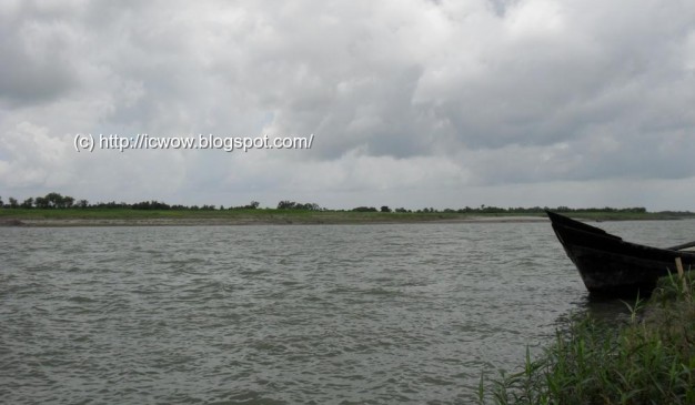
The Padma River (Bengali: পদ্মা Pôdda) is a major trans-boundary river in Bangladesh. It is the main distributary of the Ganges (Bengali: গঙ্গা Gôngga), which originates in the Himalayas. The Padma enters Bangladesh from India near Chapai Nawabganj. It meets the Jamuna (Bengali: যমুনা Jomuna) near Aricha and retains its name, but finally meets with the Meghna (Bengali: মেঘনা) near Chandpur and adopts the name ‘Meghna’ before flowing into the Bay of Bengal. Three side of the shariatpur is bounded by river. Padma river is bounded Shariatpur by various name such as Padma, Meghna & kirtinasha.
)
)