How to go
Referred how to go (overall information) from Shariatpur District. Click here
How To Reach: শরীয়তপুর জেলা
It can be said that the communication system of Shariatpur was backward until 1992 definitely. There was only 3 km of road facilities in the district. The street was created as a result of the gradual improvement in the district. However, in every district, union, even with most of the rural road, network has been developed. Different regions of the country to the east of the capital and other districts Shariyatpur travel was the primary cause of water. Kamcarastaya be spies of the public at least 35 kilometers on foot Angaria Latest from the law suit was to launch in Madaripur. Back to Faridpur Sadar, Shariyatpur days would at least some villagers. With the gradual development of the street, was established ebansariyatapure district has reduced the problem. The boats was the main vehicle for rainy season. Before 1950, the region adjacent to the boat janasadharanagayanara Chandpur, Dhaka or in Narayanganj, had to travel. Downstream by boat south of the country, the business was in Barisal. Over time, with boat launches and steamers were replaced. Before bhojesbara, Sureshwar and pattite steamers were Gorge. But does allow the sthaneara steamer. In 1991, the new steamer pattite crowd. SHARIATPUR rainy season, WAPDA Wharf, Angaria, bhojesbara, Naria, bhedarganj, laukhola, damudya, Sureshwar, bandana, and the launch of the space to navigate through different places. Only in the dry season Sureshwar, WAPDA Ghat, laukhola and bandana launch crowd. The bahananauka rainy season. Since the trip was a little easier now going trawlers. In the dry season, however, can move rickshaw through the streets of mud. How many police with all the facilities so you can walk the streets. Shariatpur be done to live up to Sureshwar Madaripur movement. Baby or assessment can be collected from there. Through to the launch of a long time Shariyatpur public capital. Sureshwar dry season, WAPDA Ghat, laukhola and up launches at pattihate reach the masses. The shariatpur Mawa Ghat and mangalamajhiraghata be easily used to pass on.
Sayedabad, Dhaka to Shariatpur
Glory Express Ltd.
Damudya via-shariatpur counter
09:30 Morning, Fare: 130/-
Phone: Anwar- 01913061515
Ferry Ghat:
Kathal Bari to Mawa Ghat-
1st Ferry: 09:30 Morning
2nd Ferry: 01:00 Noon
3rd Ferry: 04:00 Afternoon
4th Ferry: 08:00 Evening
Sadarghat, dhaka to Shariatpur via Launch
1. Prince of Aaolad
Route: Damudya, Shariatpur from Shadarghat
Time: 09:00 Evening (everyday)
2. Shornodip-7
Route: Damudya, Shariatpur from Shadarghat
Time: 09:00 Evening
Array
(
[0] => Array
(
[name] => Baro Aouliar Mazar
[post_id] => 8762
[post_link] => http://offroadbangladesh.com/bn/places/baro-aouliar-mazar/
[thumb_link] => http://offroadbangladesh.com/wp-content/uploads/2015/05/baro-awlia-300x169.jpg
[post_content] =>
From early ages it's very familiar that Munshiganj was a sacred place for Hindu and Buddha religious people. simultaneously, it was also famous for some Muslim religious saint as well. The most ancient mark of Muslim civilization of Vikrampur is the "Tetul Tolar Mazar" (তেতুল তলার মাজার) also known as "Baro Aouliar Mazar"(বারো আওউলিয়ার মাজার) in Boro Keoar village under Munshiganj district.
This place is believed to be a very sacred place from early days. There were about 12 graves divided into two rows. Muslims used to perform various religious practices like Milad, Zikr and recitation from holy Quran at this place. The Mazar was renovated in 1974. A stone was discovered at time of renovation work. The stone was inscribed with names of 12 Muslim clerics. The stone was also marked with "Kalema Tayeba" and "Hizri 421" which means the inscription of the stone dates back to 974 AD.
Munshiganj was then known as Vikrampur. The king of Vikrampur during that time was Maharajadhiraj Sree Chandra. This marks the evidence of prevalence of Muslim community in Boro Keoar village, a place infested by Buddhists mainly. Since the renovatinon in 1974, Tetul Tolar Mazar is now famous as "Baro Aouliar mazar".
The names of Arabic Muslims that was found inscribed on the stone are:
1) Shah Sultan Hossainy (R)
2) Sultan Sabbir Hossain (R)
3) Taqbeer Hashemee (R)
4) Al Hassan (R)
5) Sheikh Hossain (R)
6) Abul Hashem Hossainy (R)
7) Hafez Abu Bakar Siddique (R)
8) Hazrat Yaseen (R)
9) Obayed Ibn Muslim (R)
10) Hazrat Abdul Halim (R)
11) Hazrat Shahadat Hossainy (R)
12) Hazrat Abdul Kahar Al Bagdadi (R)
)
[1] => Array
(
[name] => Shrine of Hazrat Shah Mokdum (Ra)
[post_id] => 2999
[post_link] => http://offroadbangladesh.com/bn/places/shrine-of-hazrat-shah-mokdum-ra/
[thumb_link] => http://offroadbangladesh.com/wp-content/uploads/2015/02/shah-makhdum-shrine2-300x224.jpg
[post_content] => Shrine of Hazrat Shah Mokdum (Ra) can be termed as a Mazar or Dorga which is situated around the grave of Hazrat Shah MokdumRuposh (Ra). He initiated Islam in the Rajshahi region. It is said that he came to Rajshahi by sitting on top of Crocodile. Many crocodile are stored in the famous Dighi which is next to the mazar of Shah Mokdum (Ra).
)
[2] => Array
(
[name] => {:en}Tomb of Khan Jahan{:}{:bn}খান জাহানের দরগা{:}
[post_id] => 1519
[post_link] => http://offroadbangladesh.com/bn/places/khan-jahans-tomb/
[thumb_link] => http://offroadbangladesh.com/wp-content/uploads/2015/02/Ulug-Khan-Jahans-Tomb-1-300x225.jpg
[post_content] => {:en}
Tomb of Khan Jahan stands on a high artificial mound, as mainly known as the Dargah complex of Khan Jahan. The complex consists of the square tomb building of Khan Jahan himself; a case of Muhammad Tahir, his diwan; a single-domed mosque and the so-called kitchen. It measures as 13.7 meters height and 9.1 meters width. The four exterior angles of the building are maintained with solid circular towers. There are four walls which have a thickness of 2.4 meter, have stone casings up to the height of about 0.9 meter for preventing the building from ground moisture. The ground moisture is common in the humid climate of south Bengal. It is located on the northern bank of the so-called Thakur dighi and is surrounded by an outer wall of 67.1 meter from east to west and 64.7 meter from north to south.
It was a rectangular structure of 12.2m by 8.5m with circular towers on the exterior angles. What the building was actually intended for, is unknown. A local tradition relates that in the last years of his life Khan Jahan dwelt in the building, where he now buried, and used the adjacent building as his kitchen. About a century ago, the building was known to have been used for the same purpose by two Faqirs, who then looked after the mosque and the tomb.
{:}{:bn}
কথিত ঠাকুরদীঘির উত্তর তীরে খান জাহানের দরগা অবস্থিত। এই দরগাটি পূর্ব থেকে পশ্চিমে ৬৭.১ মিটার এবং উত্তর থেকে দক্ষিনে ৬৪.৭ মিটার দীর্ঘ দেয়াল দিয়ে ঘেরা। খান জাহানের দরগা কমপ্লেক্সটি উঁচু মাটির ঢিবির উপর অবস্থিত। এই কমপ্লেক্সে অবস্থিত একটি বর্গক্ষেত্র আকারের ভবনে খান জাহানের সমাধি, তাঁর দেওয়ান মুহাম্মাদ তাহিরের সমাধি, একটি এক গম্বুজবিশিষ্ট মসজিদ এবং একটি কথিত রান্নাঘর রয়েছে। খান জাহানের সমাধিটির প্রতিটি দিকের মাপ বাইরে থেকে ১৩.৭ মিটার এবং ভেতর থেকে ৯.১ মিটার। ইট দিয়ে নির্মিত এই ভবনটি দরগা কমপ্লেক্সের প্রাণকেন্দ্র। ভবনটির চার কোণায় চারটি গোলাকার টাওয়ার রয়েছে। এছাড়া ভবনটির চার দেয়ালের প্রতিটির পুরুত্ব ২.৪ মিটার এবং মাটির আদ্রতা থেকে রক্ষা করতে দেয়ালের ০.৯ মিটার উচ্চতা পর্যন্ত পাথরের আবরন ব্যবহার করা হয়েছে। দক্ষিনবঙ্গের আদ্র আবহাওয়ায় মাটির আদ্রতা একটি সাধারণ ব্যাপার।
কি উদ্দেশ্যে ভবনটি নির্মিত হয়েছিল সেটি জানা যায়নি। স্থানীয়দের কাছ থেকে জানা যায় জীবনের শেষ সময়ে খান জাহান আলী এই ভবনে বাস করতেন এবং পাশের ভবনটিকে রান্নাঘর হিসেবে ব্যবহার করতেন। মৃত্যুর পর খান জাহান আলীকে এই ভবনেই সমাহিত করা হয়। জানা যায় প্রায় শত বছর পূর্বে মসজিদ এবং দরগার দেখাশোনার কাজে নিয়োজিত দুজন ফকির একই উদ্দেশ্যে এই ভবনটিকে ব্যবহার করতেন।
{:}
)
[3] => Array
(
[name] => {:en}The Shrine of Lalon Fakir{:}{:bn}লালন ফকিরের আখড়া{:}
[post_id] => 1885
[post_link] => http://offroadbangladesh.com/bn/places/the-shrine-of-lalon-fakir/
[thumb_link] => http://offroadbangladesh.com/wp-content/uploads/2015/02/Shrine-of-Lalon-Fakir5-225x300.jpg
[post_content] => {:en}
The Shrine of Lalon Fakir is located in Kushtia district of Khulna division close to Kushtiya Railway Station. Lalon Fakir was born in 1774 and died in 1890. The details of Lalon’s early life are debatable and not possible to verify. He had many qualities, a spiritual leader, mystic poet, reformer and composer of Baul songs.
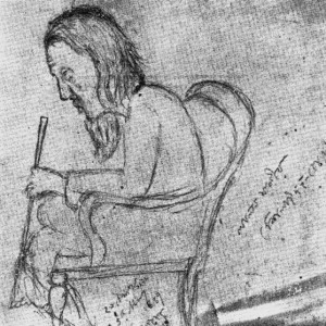
Researchers say that, It is said by locals that Lalon was born into a Kayastha family in the Bharora village in Kushtia. The Lalon festival is held every year at the Lalon Akhra in Kushtia every year where Bauls and admirers of Lalon from different parts of the country gather. Many singers sing Bauls songs that hold audience spellbound.
{:}{:bn}খুলনা বিভাগের কুষ্টিয়া জেলার রেলস্টেশনের কাছে লালন ফকিরের আখড়া অবস্থিত। তিনি ছিলেন বহু গুনের অধিকারী। যেমনঃ তিনি ছিলেন একজন আধ্যাত্মিক নেতা, একজন জাদুকরি কবি, একজন সংস্কারক এবং বাউল গানের রচয়িতা। গবেষকরা বলেন লালন ফকির ১৭৭৪ সালে জন্ম গ্রহন করেন এবং ১৮৯০ সালে মৃত্যুবরন করেন। লালনের জীবনের প্রথম দিকের বর্ণনা নিয়ে বিতর্ক রয়েছে যা খণ্ডানো সম্ভব হয়নি।
স্থানীয়রা বলেন, কুষ্টিয়ার ভারোরা গ্রামের এক কায়াস্থ পরিবারে জন্মগ্রহন করেন লালন। প্রতি বছর কুষ্টিয়ার লালনের আখড়ায় লালন উৎসব পালিত হয় যেখানে দেশের বিভিন্ন স্থান থেকে বাউল এবং লালনের ভক্তরা জড়ো হন। অনেকেই সেসময় বাউল গান গেয়ে থাকে যা শ্রোতাদের মুগ্ধ করে।{:}
)
)


