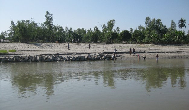
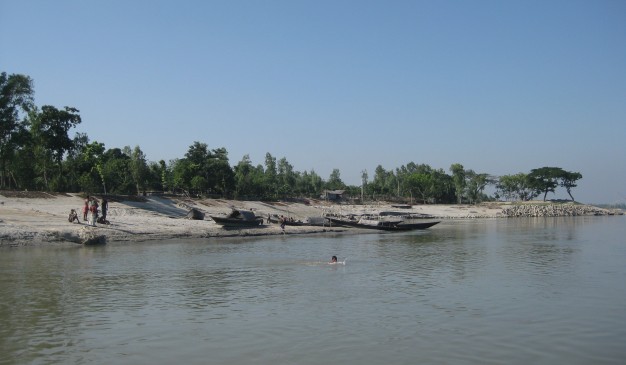
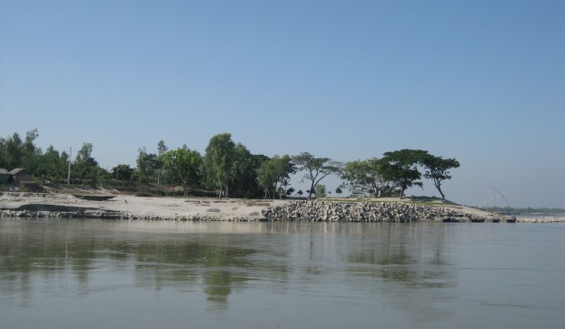
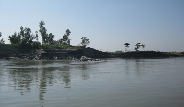
Array
(
[0] => Array
(
[name] => Arial khan River
[post_id] => 6182
[post_link] => http://offroadbangladesh.com/bn/places/arialkha-river/
[thumb_link] => http://offroadbangladesh.com/wp-content/uploads/2015/04/Arial-Kha-River-300x225.jpg
[post_content] =>
It is located in the main town of Madaripur District. Most of the major districts are established around a river. Madaripur is not alike from those. This simple but beautiful district is found around the river "Arial Khan". Both of the banks are slapped by the almost overflowing water from the river. This river meandered the district all around and where ever you visit the district, you'll find the river or a branch of the river.
"Arial Khan" is originated from the River Padma, and flowed through several southern districts from Bangladesh. After crossing Ferry from "Mawa" you have to cross the "Arial Khan" Bridge to connect with southern portion of the country. Also, just near from the district Madaripur, there is a Ferry over "Arial Khan" to connect with another district Sariatpur.
)
[1] => Array
(
[name] => River Turag
[post_id] => 7172
[post_link] => http://offroadbangladesh.com/bn/places/river-turag/
[thumb_link] => http://offroadbangladesh.com/wp-content/uploads/2015/04/Turag-River-Dhaka-021-300x225.jpg
[post_content] =>
River Turag (তুরাগ নদী) is an upper tributary river of the Buriganga River, and flows beside the Dhaka. The condition of the river is not good during the dry season. It uses to be polluted severely, and the water seems black in most of the places with a pungent smell.
The river Turag uses to inundate it’s both bank during the rainy season. Though the river is a narrow one, but for this inundation it looks like a massive river during this time. Lot of fishermen use to catch fish from this river. But due to the pollution (from industry around) the count of fish decreasing day by day. That's why those fishermen are struggling these days for fishing and migrating into other occupations for living.
)
[2] => Array
(
[name] => {:en}Kocha River{:}{:bn}কচা নদী{:}
[post_id] => 9153
[post_link] => http://offroadbangladesh.com/bn/places/kocha-river/
[thumb_link] => http://offroadbangladesh.com/wp-content/uploads/2015/05/06.-River-kocha1-300x225.jpg
[post_content] => {:en}
Kocha River is a much larger river from the Southern part of our Bangladesh. It is created when the two famous rivers Modhumoti and the Shondha merged together near at the Hularhat (হুলারহাট). After converging the two rivers it got a new name Kocha (কচা নদী) and carrying this new name until it falls into the Bay of Bengal.
Most of the main rivers from our Southern Bangladesh are having bridge on them to ease the communication. But for some unknown reason, this river Kocha (কচা নদী) is not having any bridge. And the communication between the Bagerhat (বাগেরহাট) or Pirojpur (পিরোজপুর) and Barisal (বরিশাল) is hugely dependent upon this river. One has to wait for around 30 minutes to 2 hours to cross this river. Where as a bridge can reduce this duration into few minutes.
There is only one ferry that is dealing all the transportation. It will take around 15-20 minutes to cross the river through Ferry. GPS coordinate of the river and the ferry ghat is around this (22°34'35.51"N, 90° 1'55.49"E).
{:}{:bn}
বাংলাদেশের দক্ষিন ভাগের একটি অন্যতম বড় নদীর নাম কচা নদী। হুলারহাটের কাছে জনপ্রিয় দুটি নদী মধুমতি নদী এবং সন্ধ্যা নদীর মিলনের ফলে এই নদীটির সৃষ্টি হয়। বঙ্গোপসাগরে মিলে যাওয়া পর্যন্ত এই নদীটি কচা নদী হিসেবেই বয়ে গিয়েছে।
যোগাযোগ ব্যবস্থার সুবিধার্থে দক্ষিন বাংলাদেশে অবস্থিত বেশীরভাগ প্রধান নদীর উপরেই সেতু রয়েছে। তবে, অজ্ঞাত কারনে কচা নদীর উপর কোন সেতু নেই যদিও বাগেরহাট অথবা পিরোজপুরের সাথে বরিশালের যোগাযোগ রক্ষার ক্ষেত্রে এই নদীটির ভুমিকা অপরিসীম। এই নদীটি অতিক্রমের জন্য কখনো কখনো আধ ঘণ্টা থেকে দুই ঘণ্টা পর্যন্ত অপেক্ষা করতে হয়। অথচ একটি সেতু থাকলে নদীটি অতিক্রম করতে মাত্র কয়েক মিনিট সময়ের প্রয়োজন হতো।
একটি মাত্র ফেরির মাধ্যমে কচা নদীতে সবধরনের পণ্য ও যাত্রী পরিবহন করা হয়ে থাকে। ফেরীতে করে এই নদী অতিক্রম করতে সময় লাগে ১৫ মিনিট থেকে ২০ মিনিট। কচা নদী এবং ফেরি ঘাটের জিপিএস অবস্থান হলো (২২°৩৪'৩৫.৫১"উ, ৯০°১'৫৫.৪৯"পু)।
{:}
)
[3] => Array
(
[name] => Karotoya River
[post_id] => 1149
[post_link] => http://offroadbangladesh.com/bn/places/karotoya-nodi/
[thumb_link] => http://offroadbangladesh.com/wp-content/uploads/2015/01/BD_Korotoa_River-300x225.jpg
[post_content] =>
Karatoya River (also spelt Korotoa) (Bengali:
করতোয়া নদী), a small stream in Rajshahi Division of Bangladesh, was once a large and sacred river. A channel of it presently flows by the ancient ruins of Mahasthangarh (or Pundranagara, ancient capital of Pundravardhana) in Bogra District. The
Karatoya mahatmya bears testimony to its past greatness. In the
Mahabharata it is mentioned that a visit to the Karatoya after three days’ fast produces the same merit as an aswamedha (horse killing) sacrifice. Another ancient city, Sravasti, may have been located on the banks of the Karatoya, north of Mahasthangarh. However, there is a controversy about the possible location of Sravasti.
The Karatoya, known as Phuljhur rises in the Baikunthapur jungles in the extreme north-west of Jalpaiguri district (West Bengal, India) and forms for some distance the boundary between Dinajpur and Rangpur districts. It, then, meanders through Rangpur and Bogra. In the south of Bogra district, it receives the Halhalia and the united stream is then known as Phuljhur. It leaves Bogra at Chanda kona and flowing in a southerly direction past Raiganj and Shujapur is, as already mentioned, joined by lchhamati at Nalka. The Phuljhur then flows south past the important village of Ullapara, a few miles below which it joins the Hurasagar at Narnia after a course of about 64 kilometres (40 mi) in this district. After this junction, it takes the name of Hurasagar and passing close by Shazadpur and Hera joins the Jamuna near Bera.
The Karatoya is mentioned in the Puranas and had a high repute for sanctity. It was the eastern boundary of the old kingdom of Paundravardhana, the country of the Paundras which it separated from Kamrupa. It is shown in Van Den Brouk's map of Bengal (C, 1660) as flowing into the Ganges and in fact. before the destructive floods of 1787 it brought down to the Atrai and to the Ganges a great volume of Teesta water. Since the main stream of the Teesta was dirverted to the east in 1787, the Karatoya and the Phuljhur have gradually silted up. and they are at the present day rivers of minor importance. One channel, which joins the Baral, 48 kilometres (30 mi) east of Pabna. is still called indifferently the Buri Teesta or old Teesta and the Karto or Karatoya. Traces of an old channel, for which the name of the Karatoya is claimed, are also pointed out in the Chatmohar thana, where it appears to have been obliterated by the Baral.
)
)