Brief
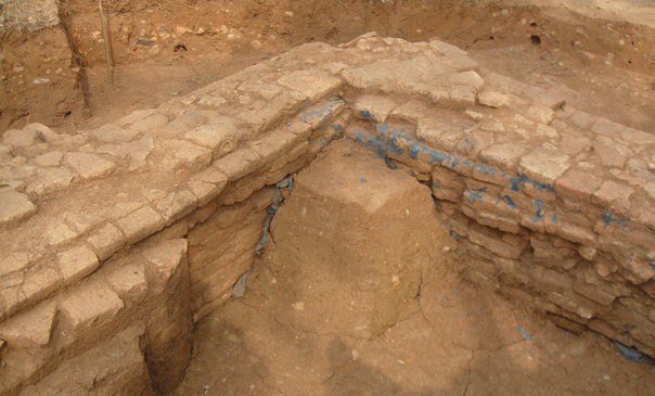
দীর্ঘ খননের পর এখানে প্রায় আড়াই হাজার বছরের পুরাতন একটি শহর আবিষ্কৃত হয়। মাটির ৬০০ মিটার গভীরে মাটির তৈরি একটি দেয়াল এবং চারটি উঁচু প্রতিরক্ষামুলক বাঁধ পাওয়া যায়। প্রাচীন প্রতিরক্ষামুলক বাঁধের বেশীরভাগ ধ্বংস হয়ে গেলেও কিছু স্থানে এখনও পাঁচ থেকে সাত ফুট উঁচু দেয়ালের প্রমান পাওয়া যায়। প্রতিরক্ষা দেয়ালটি পরিখা দিয়ে ঘেরা ছিল তবে সময়ের সাথে সাথে পরিখাগুলো ভরাট হয়ে যায় এবং স্থানটি ধানক্ষেতে পরিণত হয়।
উয়ারি-বটেশ্বর দুর্গের পশ্চিম এবং দক্ষিন-পশ্চিম দিকে অসম রাজার গড় নামে পরিচিত ৫.৮ কিলোমিটার দীর্ঘ, ২০ মিটার প্রশস্ত এবং ১০ মিটার উঁচু একটি মাটির তৈরি দেয়াল রয়েছে। এখন পর্যন্ত পুরাতন ব্রহ্মপুত্র নদীর তীরে অবস্থিত উয়ারি-বটেশ্বর শহরের বিভিন্ন স্থানে প্রায় ৫০টি প্রত্নতাত্ত্বিক স্থান আবিষ্কৃত হয়েছে। প্রত্নতাত্ত্বিক স্থানগুলো থেকে প্রতীয়মান হয় যে প্রাচীনকালে মানুষেরা বন্যামুক্ত অঞ্চলে বসতি স্থাপন করেছিল যা থেকে সেসময়ের মানুষের শহরভিত্তিক পরিকল্পনা সম্পর্কে ধারনার প্রমান পাওয়া যায়। ভারতের উত্তর প্রদেশের আল্লাহবাদ অঞ্চলে এবং বগুড়ার মহাস্থানগড়ে (পুণ্ড্রনগরে) একই ধরনের বসতির নিদর্শন দেখা যায়। উয়ারি বটেশ্বরে আবিষ্কৃত বাকি প্রত্নতাত্ত্বিক নিদর্শনগুলো মাটির নীচে রয়েছে। ধারনা করা হয় যে, এই এলাকায় বসবাসকারীরা কৃষির উপর ভিত্তি করে জীবনধারন করেছিল এবং তাঁদের উৎপাদিত উদ্বৃত্ত খাদ্য শস্য এখানে বসবাসকারী ব্যবসায়ী, পাদ্রী এবং রাজ্যের কর্মকর্তা ও কর্মচারীদের চাহিদা পুরন করত।
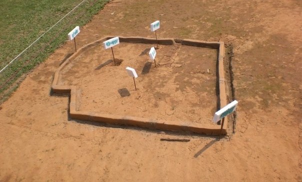
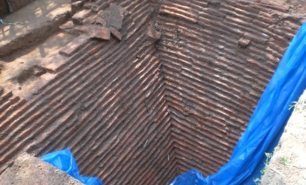
সাম্প্রতিক সময়ে খননকালে উয়ারি-বটেশ্বর থেকে বেশকিছু বৌদ্ধ বিহার, প্রাচীন পদ্ম মন্দির, এবং উল্টো পিরামিডের নিদর্শন আবিষ্কৃত হয়। তবে, স্থায়ীভাবে সংরক্ষণ না করার কারনে এসব নিদর্শন আবারো মাটির নীচে চাপা পড়েছে।
প্রাচীন এই অঞ্চলের বাসিন্দারা উন্নত প্রযুক্তিগত জ্ঞানের সাথে পরিচিত ছিল। যেমনঃতারা পাথর কেটে পুতি তৈরি করেছিল। খননের পর এখান থেকে মূল্যবান পাথরের পুতি তৈরির কাচামাল, এবং বিভিন্ন আনুষঙ্গ আবিষ্কৃত হয় এবং এ থেকে প্রতীয়মান হয় যে হয়ত সেসময় এখানে পুতি এবং তাবিজ তৈরির বড় কোন কারখানা ছিল।
এছাড়া এখানকার অধিবাসীরা বিভিন্ন রাসায়নিক দিয়ে পালিশের কাজও করেছিল। মৃৎশিল্পের কাজ করার সময় উন্নত প্রযুক্তির মাধ্যমে তাপমাত্রা নিয়ন্ত্রন করা ছাড়াও এখানকার অধিবাসীরা ধাতু গলিয়ে পয়সা তৈরি এবং লোহাকে প্রক্রিয়াজাত করতে পারতো।
উয়ারি-বটেশ্বর এবং অসম রাজার গড়ের অবস্থান থেকে প্রমান পাওয়া যায় যে এখানকার অধিবাসীদের জ্যামিতিক জ্ঞান শুধু প্রখরই ছিলনা বরং তারা কারিগরি এবং বৈজ্ঞানিক জ্ঞানও ধারন করতেন এবং বেশকিছু কারিগরি কর্মকাণ্ডে তাঁদের শৈল্পিক এবং সৌন্দর্যবোধ ছিল চোখে পরার মত। এখানকার অধিবাসীদের ব্যবহার করা কাল রঙের পলিশ শহরের সংস্কৃতির সাথে সম্পর্কিত ছিল।
এখানকার বাসিন্দাদের ব্যবহার করা কালো পলিশের সামগ্রী পাওয়া গিয়েছিল উপমহাদেশের দ্বিতীয় নগরায়নের সময়কার বিভিন্ন প্রত্নতাত্ত্বিক নিদর্শনে। বলা হয়ে থাকে যে দ্বিতীয় নগরায়নের সময় শাসক এবং ব্যবসায়ীদের চাহিদা মেটাতে এসব কালো পলিশ উৎপাদন করা হত। পুরাতন ব্রহ্মপুত্র নদীর উপস্থিতির কারনে ধারনা করা যায় যে উয়ারি-বটেশ্বর ছিল একটি নদী বন্দর এবং বাণিজ্য কেন্দ্র।
অকীক, ফটিক, জ্যাসপার, কার্নেলিয়ান, এমেথিসট, চালেসদনি প্রভৃতি মূল্যবান রত্ন দিয়ে তৈরি মূল্যবান পাথরের পুতি আবিষ্কারের ফলে ক্যাম্ব্রিজ বিশ্ববিদ্যালয়ের দক্ষিন এশিয়া বিষয়ক প্রত্নতত্ত্ব বিভাগের অধ্যাপক দিলীপ চক্রবর্তী মনে করেন উয়ারি বটেশ্বর সম্ভবত একটি ‘সুয়ানগর’ অর্থাৎ বাণিজ্যকেন্দ্র ছিল যা দ্বিতীয় শতকের প্রখ্যাত ভুগলবিদ টলেমি উল্লেখ করেছিলেন।
উয়ারি-বটেশ্বরে প্রাপ্ত স্যানডউইচ আকারের কাঁচের পুতি, মসৃণ মৃৎপাত্র, গুলবসান গুদাম, কাল পলিশ, বিভিন্ন ধরনের পুতি, তাবিজ এবং কানের দুল থেকে প্রতীয়মান হয় যে এই অঞ্চলটির সাথে সমসাময়িক ভারতীয় উপমহাদেশের কিছু স্থানের এবং দক্ষিন-পূর্ব এশিয়া ও ভুমধ্য অঞ্চলের যোগসূত্র ছিল। উয়ারি-বটেশ্বরে ক্যালকোলিথিক সংস্কৃতির সবচেয়ে বড় প্রমান মেলে কালো ও লাল রঙের বিভিন্ন পণ্য এবং মাটি খুঁড়ে আবাস গড়ার অভ্যাস থেকে। ভারতের মহারাষ্ট্রের ইনামগাঁওয়ে মাটিতে গর্ত করে আবাস গড়ার বেশকিছু নিদর্শন পাওয়া গিয়েছে এবং জাতিগত প্রত্নতাত্ত্বিক গবেষণা থেকে দেখা যায় যে এই অঞ্চলে এখনও গর্ত করে আবাস গড়ার সংস্কৃতি বিরাজমান। অর্ধ-শুস্ক ইনামগাঁওয়ে মাটিতে গর্ত করে আবাস গড়ার প্রমান মিললেও উয়ারি-বটেশ্বরে এরকম চর্চা বড় ধরনের প্রশ্নের জন্ম দিয়েছে কেনোনা বর্তমান প্রেক্ষাপটে উয়ারি-বটেশ্বরের মত একটি বৃষ্টিপ্রবণ অঞ্চলে এ জাতীয় গর্ত করে আবাস গড়া কতটুকুই বা বাস্তবসম্মত ছিল কেননা ভারি বৃষ্টিপাতের ফলে খোরা গর্তগুলো সহজেই পানিতে ভরে যেতো। প্রত্নতত্ত্বভিত্তিক সাহিত্য থেকে জানা যায় যে প্রায় ১৫০০ অথবা ১০০০ সালের পূর্বে ভারতীয় উপমহাদেশের আবহাওয়া ছিল শুস্ক।
উয়ারি-বটেশ্বরে দুই ধরনের মুষ্টাঘাত চিন্হিত রৌপ্যমুদ্রা আবিষ্কৃত হয়। এক ধরনের মুদ্রা হল জনপদ অথবা মুয়ারন পূর্ববর্তী মুষ্টাঘাত চিন্হিত রৌপ্যমুদ্রা। উপমহাদেশে খ্রিষ্টপূর্ব প্রায় ৬০০ থেকে ৪০০ সাল পর্যন্ত জনপদ নামক মুদ্রার প্রচলন ছিল। জনপদ নামক মুদ্রার আবিষ্কারের ফলে ধারনা করা হয় যে উয়ারি-বটেশ্বর ভারতীয় উপমহাদেশের সদোশা মহাজনপদ রাজ্যের (খ্রিষ্টপূর্ব প্রায় ৬০০ থেকে ৪০০ সাল পর্যন্ত) অংশ ছিল। উয়ারি-বটেশ্বরে সাম্প্রতিক খননকালে ক্যালকোলিথিক সংস্কৃতির মানব সভ্যতার প্রমান পাওয়া যায়।
Array
(
[0] => Array
(
[name] => Mahasthangarh
[post_id] => 1387
[post_link] => http://offroadbangladesh.com/bn/places/mahasthangarh/
[thumb_link] => http://offroadbangladesh.com/wp-content/uploads/2015/02/Mahasthangarh1-1024x768-300x225.jpg
[post_content] => Mahasthangarh (Bengali:
মহাস্থানগড় Môhasthangôṛ) is one of the earliest urban archaeological sites so far discovered in Bangladesh. The village Mahasthan in Shibganj thana of Bogra District contains the remains of an ancient city which was called Pundranagara or Paundravardhanapura in the territory of Pundravardhana. A limestone slab bearing six lines inPrakrit in Brahmi script, discovered in 1931, dates Mahasthangarh to at least the 3rd century BC. The fortified area was in use till the 18th century AD.
Together with the ancient and medieval ruins, the mazhar (holy tomb) of Shah Sultan Balkhi Mahisawar built at the site of a Hindu temple is located at Mahasthangarh. He was a dervish (holy person devoted to Islam) of royal lineage who came to the Mahasthangarh area, with the objective of spreading Islam among non-Muslims. He converted the people of the area to Islam and settled there.
Mahasthan means a place that has excellent sanctity and
garh means fort. Mahasthan was first mentioned in a Sanskrit text of the 13th century entitled
Vallalcharita. It is also mentioned in an anonymous text
Karatoya mahatmya, circumstantially placed in 12th–13th century. The same text also mentions two more names to mean the same place – Pundrakshetra, land of the Pundras, and Pundranagara, city of the Pundras. In 1685, an administrative decree mentioned the place as Mastangarh, a mixture of Sanskrit and Persian meaning fortified place of an auspicious personage. Subsequent discoveries have confirmed that the earlier name was Pundranagara or Paundravardhanapura, and that the present name of Mahasthangarh is of later origin.
Mahasthangarh, the ancient capital of Pundravardhana is located 11 km (6.8 mi) north of Bogra on the Bogra-Rangpur highway, with a feeder road (running along the eastern side of the ramparts of the citadel for 1.5 km) leading to Jahajghata and site museum. Buses are available for Bogra from Dhaka and take 4½ hours for the journey via Bangabandhu Jamuna Bridge across the Jamuna River. Buses are available from Bogra to Mahasthangarh. Rickshaws are available for local movement. Hired transport is available at Dhaka/ Bogra. Accommodation is available at Bogra. When travelling in a hired car, one can return to Dhaka the same day, unless somebody has a plan to visit Somapura Mahavihara at Paharpur in the district of Naogaon and other places, or engage in a detailed study.
It is believed that the location for the city in the area was decided upon because it is one of the highest areas in Bangladesh. The land in the region is almost 36 metres (118 ft) above sea level, whereas Dhaka, the capital of Bangladesh, is around 6 metres (20 ft) above sea level. Another reason for choosing this place was the position and size of the Karatoya, which as recently as in the 13th century was three times wider than Ganges.
Mahasthangarh stands on the red soil of the Barind Tract which is slightly elevated within the largely alluvium area. The elevation of 15 to 25 metres above the surrounding areas makes it a relatively flood free physiographic unit.
)
[1] => Array
(
[name] => {:en}Pailgaon Zamindar Bari{:}{:bn}পাইলগাঁও জমিদারবাড়ী{:}
[post_id] => 22961
[post_link] => http://offroadbangladesh.com/bn/places/pailgaon-zamindar-bari/
[thumb_link] => http://offroadbangladesh.com/wp-content/uploads/2015/11/P_20151014_130750_1_p-300x169.jpg
[post_content] => {:en}
Pailgaon Zamindar Bari is one of the remarkable old structures of Jagannathpur in Sunamganj. This 300 years old palace was established on 5.5 acres of land.
The last person of this Zamindar family was Brajendra Narayan Chowdhury. He was a famous politician at that time and a member of the congress of Sylhet too at that time.
The place is situated near the bank of Kushiara river in Sunamganj District. It is at Pailgaon Union under Jagannathpur Upazila.
History of this place: Thousand years ago, decedents of Pal Dynasty lived here. As time goes, "Das" family took their place. Pir Mohammad Badsha (Muslim Rulers) gave them the title - "Chowdhury". Ram and Sreeram were two descendants of this bloodline. One of their descendants Madhab Ram gained much popularity in his locality at that time. He did a lot of social welfare.
Their descendants Brojnath had two sons. Their named were Roshomoy Chowdhury and Sukhumoy Chowdhury. The place is locally known by the name after of Zamindar Roshomoy Chowdhury. The last ruler of the family was famous Brajendra Narayan Chowdhury.
{:}{:bn}প্রাচীন পুরাকীর্তির অন্যতম নিদর্শন সুনামগঞ্জের জগন্নাথপুর উপজেলার পাইলগাঁও জমিদারবাড়ী। প্রায় সাড়ে ৫ একর ভূমির ওপর প্রতিষ্ঠিত তিন শত বছরেরও বেশী পুরানো এ জমিদার বাড়ীটি এ অঞ্চলের ইতিহাস-ঐতিহ্যের নিদর্শন ।এ জমিদার পরিবারের শেষ জমিদার ব্রজেন্দ্র নারায়ণ চৌধু রী ছিলেন প্র খ্যাত শিক্ষাবিদ ও রাজনীতিবিদ। তিনি ছিলেন সিলেট বিভাগের কংগ্রেস সভাপতি এবং আসাম আইন পরিষদের সদস্য। সিলেট বিভাগের সুনামগঞ্জ জেলায় জগন্নাথপুর উপজেলার অধীন ৯ নম্বার পাইলগাও ইউনিয়নের পাইলগাও গ্রামে ঐতিহ্যবাহি এ জমিদারীর অবস্থান। জমিদার বাড়ী দক্ষিণ দিকে সিলেটের কুশিয়ারা নদী বহমান। প্রখ্যাত ঐতিহাসিক অচ্যূতচরণ চৌধুরী পাইলগাও জমিদার বংশের রসময় বা রাসমোহন চৌধুরী হতে প্রাপ্ত সূত্রেলিখেছেন যে; পাইলগাওয়ে বহুপূর্বকালে পাল বংশীয় লোক বসবাস করত। এ গোষ্টিয় পদ্মলোচন নামক ব্যক্তির এক কন্যার নাম ছিল রোহিণী। কোন এক কারণে রাঢ দেশের মঙ্গলকোট হতে আগত গৌতম গোত্রীয় কানাইলাল ধর রোহিণীকে বিবাহ করত গৃহ-জামাতা হয়ে এখানেই বসবাস শুরুকরেন। কানাইলাল ধরের আট পুরুষ পরে বালক দাস নামের এক ব্যক্তির উদ্ভব হয়। এ বালক দাস থেকে এ বংশ বিস্তৃত হয়। বালক দাসের কয়েক পুরুষ পর উমানন্দ ধর ওরফে বিনোদ রায় দিল-ীর মোহাম্মদ শাহ বাদশা কর্তৃ ক চৌধুরী সনদ প্রাপ্তহন। বিনোদ রায়ের মাধব রাম ও শ্রীরাম নামে দুই পুত্রের জন্মহয়। তার মধ্যেমাধব রামজনহিতকর কর্মপালনে নিজ গ্রাম পাইলগাঁও এ এক বিরাট দীঘি খনন করে সুনাম অর্জন করেন। তার দেয়া উক্তদীঘি আজও ঐ অঞ্চলে মাধব রামের তালাব হিসেবে পরিচিতহচ্ছে। মাধব রামের দুই পুত্র মদনরাম ও মোহনরাম । উক্ত মোহনরামের ঘরে দুর্লভরাম, রামজীবন, হুলাসরাম ও যোগজীবন নামে চার পুত্রের জন্ম হয়। এই চার ভাই দশসনা বন্দোবস্তের সময় কিসমত আতুয়াজানের ১থেকে ৪ নং তালুকের যতাক্রমে বন্দোবস্তগ্রহন করে তালুকদার নাম ধারণ করে। এদের মধ্যে হুলাসরাম বানিয়াচং রাজ্যের দেওয়ানি কার্যালয়ে উচ্চ পদের কর্মচারীনিযুক্ত হন। হুলাসরাম চৌধুরী বানিয়াচং রাজ্যের রাজা দেওযান উমেদ রাজারঅনুগ্রহে আতুয়াজান পরগণায় কিছু ভূমি দান প্রাপ্তহন। হুলাসরামের প্রাপ্তভূমির কিছু কিছু চাষযোগ্যও কিছু ভূমি চাষ অযোগ্যছিল। পরবর্তিতে হুলাসরাম চাষ অযোগ্য ভূমিগুলোকে চাষযোগ্যকরে তুললে এগুলোই এক বিরাট জমিদারীতে পরিণত হয়ে উঠে। হুলাস রামের ভাতুষ্পুত্রবিজয়নারায়ণের একমাত্রপুত্রব্র জনাথ চৌধুরীজমিদারি বর্ধিত করে এক প্রভাবশালী জমিদারে পরিণত হন। ব্রজনাথ চৌধুরীর দুইপুত্ররসময় ও সুখময় চৌধুরী। রসময় চৌধুরীর পুত্র ব্রজেন্দ্রনারায়নই ছিলেন এবংশের শেষ জমিদার।{:}
)
[2] => Array
(
[name] => {:en}Jagaddal Vihara{:}{:bn}জগদ্দল বিহার{:}
[post_id] => 3652
[post_link] => http://offroadbangladesh.com/bn/places/jogoddol-vihara/
[thumb_link] => http://offroadbangladesh.com/wp-content/uploads/2015/02/Jogoddol-Bihar-Naogaon-01-300x225.jpg
[post_content] => {:en}
Jagaddal Vihara is located approximately 55km away from Noagaon Zilla sadar. It is a very ancient site. Locals call it as remnants of Bot Krishna Zamider Bari. Jagaddala Mahavihara was a Buddhist monastery founded by the later kings of the Pala dynasty, possibly Rampala (1077-1120), most likely at a site near the present village of Jagaddal in Dhamurhat Upazila in the north-west Bangladesh on the border of India, near Paharpur. Jagaddala Mahavihara (fl. late 11th century - mid-12th century) was a Buddhist monastery and seat of learning in Varendra, a geographical unit in present north Bengal. It was founded by the later kings of the Pāla dynasty, probably Ramapala (c. 1077-1120), most likely at a site near the present village of Jagdal in Dhamoirhat Upazila in the north-west Bangladesh on the border with India, near Paharapur. Some texts also spell the name Jaggadala.
A large number of monasteries or viharas were established in ancient Bengal and Magadha during the four centuries of Pala rule in North-eastern India (756-1174 AD).Dharmapala (781-821) is said to have founded 50 viharas himself, including Vikramashila, the premier university of the era. Jaggadala was founded toward the end of the Pāla dynasty, most likely by Rāmapāla (c. 1077-1120). According to Tibetan sources, five great Mahaviharas stood out: Vikramashila; Nalanda, past its prime but still illustrious, Somapura, Odantapurā, and Jagaddala. The five monasteries formed a network; "all of them were under state supervision" and their existed "a system of co-ordination among them ... it seems from the evidence that the different seats of Buddhist learning that functioned in eastern India under the Pāla were regarded together as forming a network, an interlinked group of institutions," and it was common for great scholars to move easily from position to position among them.
Jagaddala specialized in Vajrayana Buddhism. A large number of texts that would later appear in the Kanjur and Tengjur were known to have been composed or copied at Jagadala. It is likely that the earliest dated anthology of Sanskrit verse, the Subhāṣitaratnakoṣa, was compiled by Vidyākara at Jaggadala toward the end of the 11th century or the beginning of the 12th.
{:}{:bn}
জগদ্দল বিহার নওগাঁ জেলা সদর থেকে প্রায় ৫৫ কিলোমিটার দূরে অবস্থিত একটি প্রাচীন স্থান। স্থানীয়রা এটিকে বটকৃষ্ণ জমিদার বাড়িও বলে থাকে এবং জায়গাটিকে জজ্ঞদল হিসেবেও বলা হয়ে থাকে। বর্তমান উত্তরবঙ্গের বরেন্দ্রতে (১১শ শতাব্দীর শেষ থেকে ১২শ শতাব্দীর মধ্যে) এটি ছিল একটি বৌদ্ধ বিহার এবং শিক্ষাদান কেন্দ্র। পাল রাজবংশের রাজা সম্ভবত রামপাল (১০৭৭-১১২০) পাল শাসনামলের শেষার্ধে এটি প্রতিষ্ঠা করেন উত্তরপশ্চিম বাংলাদেশে অবস্থিত ধামরিহাট উপজেলার জাগদাল গ্রামে যে জায়গাটি ভারত সীমান্তবর্তী এবং পাহাড়পুরের নিকটে অবস্থিত।
উত্তর-পূর্ব ভারতে পাল শাসনামলের চার শতকে (খ্রিস্টপূর্ব ৭৫৬-১১৭৪) প্রাচীন বাংলা এবং মাগাধাতে অনেক বিহার প্রতিষ্ঠা করা হয়। ধর্মপাল (৭৮১-৮২১) একাই ৫০টি বিহার প্রতিষ্ঠা করেন যার মধ্যে ছিল সে সময়ের প্রধান বিশ্ববিদ্যালয় বিক্রমশীলা। তিব্বতের সূত্র অনুযায়ী পাঁচটি শ্রেষ্ঠ মহাবিহার ছিলঃ বিক্রমশীলা ছিল সেই যুগের প্রধান বিশ্ববিদ্যালয়; নালান্দা; সোমপুর মহাবিহার; অদন্তপুর এবং জাজ্ঞাদলা। পাল আমলে পূর্ব ভারতে শিক্ষাদানকারী সবগুলো বৌদ্ধবিহার রাষ্ট্রের তত্ত্বাবধানে ছিল এবং বৌদ্ধবিহারগুলো একটি নেটওয়ার্ক তৈরি করেছিল এবং বিহারগুলোর মধ্যে সমন্বয় ছিল এতে করে মহান মনিষীদের জন্য বৌদ্ধবিহারগুলোর মধ্যে অবস্থান বদলানো সহজ হত।
বজ্রানা বৌদ্ধশাস্ত্রে বিশেষায়িত ছিল জগদ্দল। পরবর্তীকালে জানা যায় যে কানজুর এবং তেংজুরে উল্লেখিত প্রচুর অক্ষর এই জগদ্দলেই গঠন করা হয়েছিল। সম্ভবত সাংস্কত ভাষার প্রাচীনতম সংকলন সুভাসিতারত্নকোষ জগদ্দলেই ১১শ শতাব্দীর শেষের দিকে অথবা ১২শ শতাব্দীর শুরুতে গঠন করা হয়।
{:}
)
[3] => Array
(
[name] => Lakshindarer Gokul Medh
[post_id] => 1378
[post_link] => http://offroadbangladesh.com/bn/places/lakshindarer-medh-gokul/
[thumb_link] => http://offroadbangladesh.com/wp-content/uploads/2015/02/Lakshindarer-Medh-Gokul-rakib-bd21-300x225.jpg
[post_content] => The name
Lakshindarer Gokul Medh is taken from famous folk tale Laksinder and Behula. It was excavated in 1934-1936 and it exposed the antique of a temple. It has a high podium and it can hold 172 rectangular blind cell of different types. Terracotta plaques and other objects were found while digging during the Pala period (6
th-7
th) century.
The mound derived its name from the popular romantic folk tale entitled Behula and Lakshindar. Connected with the same story is found another smaller mound, locally known as ‘Netai Dhopanir Pat’, situated to the close east of the Medh.
The mound is situated on the west of village Gokul which is about 2km to the southwest of Mahasthangarh. It was excavated in 1934-36 and has revealed the derelict relics of a temple. The remarkable feature of this temple is its high plinth accommodating 172 rectangular blind cells of various dimensions. They rise in tiers and packed solidly with earth, so as to form a lofty massive podium, crowned originally either by a shrine or a stupa, now lost.
This novel device, functionally comparable to our modern piling system, liberally used in Bengal during five centuries preceding the Muslim conquest, was found particularly suitable for the alluvial soil of Bengal by the builders to erect their sacred buildings to an imposing height much above the flood level. However, the cellular construction is not confined to Bengal only but parallel examples occur far to the west at Ahichhatra in the Bereilly district of U.P.
Terracotta plaques and other associated objects unearthed during the excavation, which are ascribed to the late Gupta period (6th-7th century A.D.), indicate that originally this stupendous ruin at the Medh constituted an imposing terraced sub-structure of a roughly cruciform plan surmounted with a central shrine of complex outline, dedicated probably to the Buddhist Faith. Over the sub-structure is an octagonal plinth which, as mentioned, may originally have carried a stupa, but now completely gone. This stupa was replaced by a square shrine ( 8.17m square outside) and porch during the Sena period (11th-12th century A.D.).
A grand staircase on the west gave access to the shrine, but the doorway of the shrine and porch was later blocked and the floor level raised to an unknown height. The excavation inside the shrine revealed a small intrusive cell containing human skeleton-probably of an anchorite-and underlying that was found a circular brick-paved pit of 3.86m in diameter. A stone-slab of 51.2cm × 46.1cm was discovered at the center of the shrine which bore 12 shallow holes with a larger hole in the center containing a tiny gold left, about an inch square. However, nothing note worthy was discovered underneath the stone-slab.
)
)