


Brief
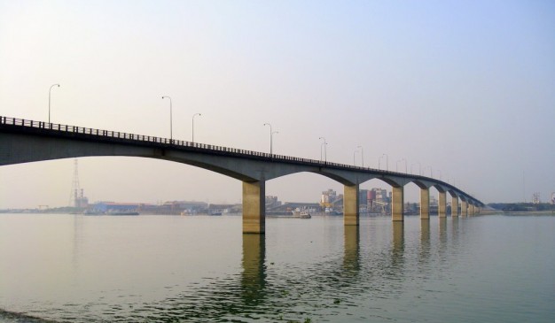
মেঘনা সেতু নামে বহুল পরিচিত এই সেতুটির দাপ্তরিক নাম হল জাপান-বাংলাদেশ মৈত্রী সেতু-১। ক্যাণ্টিলিভার ব্রিজের নকশায় নির্মিত এই সেতুতে যানবাহন এবং পথচারি চলাচলের ব্যবস্থা আছে। জাপানের সহায়তায় নির্মিত সেতুটির মোট দৈর্ঘ্য ৯০০ মিটার (২৯৫২ ফুট ৯ ইঞ্চি) এবং প্রস্থ ৯.২ মিটার (৩০ ফুট ২ ইঞ্চি। ১৯৯১ সালের ১লা ফেব্রুয়ারি সেতুটি যান চলাচলের জন্য উন্মুক্ত করে দেওয়া হয়। সেতুটির জিপিএস অবস্থান হল ২৩°৩৬.১৬২′উ ৯০°৩৬.৯৯১′পু।
২০০৪ সালে জাপান দূতাবাস পরিচালিত একটি সমীক্ষায় দেখা যায় সেতুটি নির্মাণের ফলে সেতুর আশেপাশে বসবাসকারীদের জীবন মান বৃদ্ধি পাওয়ার পাশাপাশি সেতুর আশেপাশের এলাকারও শহরিকরন হয়েছে। জরিপে অংশগ্রহনকারীরা জানিয়েছেন যে খারাপ আবহাওয়ার কারনে সেতুর উপর যান চলাচল বাধাগ্রস্থ হওয়ার ঘটনা পূর্বের চেয়ে লোপ পেয়েছে। জরিপ থেকে এও জানা যায় যে, সেতুতে চলাচলকারী ৪২% ট্রাক ঢাকা ও চট্রগ্রামের মধ্যে পণ্য পরিবহন করে থাকে।
যথাযথ রক্ষনাবেক্ষনের অভাবে এবং অধিক ওজনের যানবাহন চলাচলের জন্য সেতুটির বেশকিছু অংশে এক্সপেনশন জয়েন্ট ক্ষতিগ্রস্থ হওয়ায় ২০০৫ সালে সেতুটিতে বড় ধরনের মেরামত কাজ পরিচালনা করা হয়।
স্থাপত্যঃ ক্যাণ্টিলিভার এবং গার্ডারে নির্মিত এই সেতুতে উভয় দিকে যান চলাচল করতে পারে। সেতুটির ১৩টি স্প্যানের মধ্যে দুটি স্প্যানের দৈর্ঘ্য ২৪.২৫ মিটার (৭৯ ফুট ৭ ইঞ্চি), একটি স্প্যানের দৈর্ঘ্য ৪৮.৩ মিটার (১৫৮ ফুট ৬ ইঞ্চি), নয়টি স্প্যানের দৈর্ঘ্য ৮৭ মিটার (২৮৫ ফুট ৫ ইঞ্চি) এবং বাকি একটি স্প্যানের দৈর্ঘ্য ১৮.২ মিটার (৫৯ ফুট ৯ ইঞ্চি)। মেঘনা সেতুর মূল সড়কপথের দৈর্ঘ্য ৭.২ মিটার (২৩ ফুট ৭ ইঞ্চি)। সেতুটির ফাউণ্ডেশন নদীতলে গেঁথে দেওয়া আরসিসি প্রকোষ্ঠ এবং পাইলের উপর করা হয়েছে। সেতুটির পিলার এবং ভারবাহী স্তম্ভগুলো আরসিসি দিয়ে নির্মিত। ষড়ভুজ আকৃতির সেতুটির একেকটি ভারবাহী বস্তুর দৈর্ঘ্য ১১ মিটার (৩৬ ফুট ১ ইঞ্চি) এবং প্রস্থ ৩.২ মিটার (১০ ফুট ৬ ইঞ্চি)। পিলারের সাথে যুক্ত সেতুটির পার্শ্ব দেয়াল আরসিসি দিয়ে তৈরি। আরসিসি পোস্ট প্রকৃতির মেঘনা সেতুর রেলিং স্টিলের তৈরি । পানি নিষ্কাশনের ব্যবস্থা সহ সেতুটির উভয়দিকে হাঁটার জন্য ০.৮০ মিটার (২ ফুট ৭ ইঞ্চি) প্রস্থ ফুটপাথ রয়েছে।
অর্থনীতির উপর প্রভাবঃ মেঘনা সেতু উদ্বোধনের পর এই সেতুতে এবং ১ নং জাতীয় মহাসড়কে যান চলাচল উল্ল্যেখযোগ্য পরিমানে বৃদ্ধি পায়। তবে ২০০২ সালে সেতুটিতে চলার জন্য টোলের পরিমান বৃদ্ধির পর যান চলাচল কমে আসে। উদাহরন হিসেবে বলা যায় যে ১৯৯৭ সালের এপ্রিলে ২৪ ঘণ্টায় গড়ে প্রায় ১০১৪৯ টি সব ধরনের যানবাহন সেতুটি অতিক্রম করে। অন্যদিকে ২০০৪ সালের মার্চে ৯৭০৪ টি যানবাহন গড়ে প্রতিদিন এই সেতুটি অতিক্রম করে।
Array
(
[0] => Array
(
[name] => Panam Bridge
[post_id] => 11590
[post_link] => http://offroadbangladesh.com/bn/places/panam-bridge/
[thumb_link] => http://offroadbangladesh.com/wp-content/uploads/2015/07/120-300x169.jpg
[post_content] =>
Panam area is formed as a part of the Muslim metropolis, developed on the south of the old city, and perhaps constituted as the place of residence of the early Muslim governors'. After the Mughal conquest of Sonargaon (1611), the Panam area was connected with the ruling metropolis by construction of highways and bridges. Panam still possesses three brick bridges belonging to the Mughal period: Panam Bridge, Dalalpur Bridge and Panamnagar Bridge. The existence of these bridges and the canals enclosing the site on three sides is indicative of its being a suburban area of the medieval city.
Panam Bridge a fine old bridge constructed originally over a canal on a village road from Hajiganj to Baidyer Bazar, now located a little further to the east of Habibpur on a pucca road between Companyganj and Bari Majlis in Sonargaon. It was originally known as Companyganj ka Pul (কোম্পানিগঞ্জের পুল). The Bridge measuring about 53 meter in length and 5 metre in breadth consists of three arches, the middle arch being wider and higher providing easy passage of boats underneath. The steep roadway is formed of bricks circularly arranged. The architectural feature places the bridge to belong to the Mughal period (17th century).
)
[1] => Array
(
[name] => Teesta Railway Bridge
[post_id] => 6434
[post_link] => http://offroadbangladesh.com/bn/places/teesta-railway-bridge/
[thumb_link] => http://offroadbangladesh.com/wp-content/uploads/2015/04/tista-barrage1-300x200.jpg
[post_content] =>
Teesta Railway Bridge is the third largest railway bridge of the country lengths about 2000 feet and constructed in the year 1834.
In 1978, to manage load of road vehicles for Lalmonirhat, Kurigram and beyond by ferry, the then president Ziaur Rahman instructed the Railway and Roads authority to set wooden sleepers in the rail bridge between the rails for all types of vehicular movement. Same year, March 4, President Ziaur Rahman inaugurated the bridge for vehicular movement. The bridge restores the communication from divisional headquarters of Rangpur with two districts, Lalmonirhat and Kurigram.
The bridge is now in broken-down condition and needs major repair. For motor vehicles construction of a road bridge began next to it in 2006 for completion by 2009 at a cost of Tk 1.22 billion which is now expected to be opened in June 2012.
)
[2] => Array
(
[name] => Mirkadim Bridge
[post_id] => 8217
[post_link] => http://offroadbangladesh.com/bn/places/mirkadim-bridge/
[thumb_link] => http://offroadbangladesh.com/wp-content/uploads/2015/05/Mirkadim-Bridge-11-300x200.jpg
[post_content] =>
Mirkadim bridge (মীরকাদিম ব্রিজ) spans the Mir Kadim canal (creek) which runs from Mir Kadim to Tangibari. It connects the village Abdullahpur and Panam area of Rampal Union Parishad under Munshigonj District. It is situated at a distance of about 5.50 km from the district headquarters. The local tradition claims it to have been built by King Ballal Sen, but the architectural features belie the local tradition. The bridge can architecturally be attributed to the Mughal period, not earlier than 17th century. The 53m long bridge consists of a central pointed arch of 4.40m span with two side arches of 2.25m span each. The central arch is 0.40m high from the water level of the creek and at present 31m wide. It is 6.15m wide with each wing measuring 16.80m in length. The central arch is flanked by an octagonal pilaster on each side. Similarly each of the side arches has a pilaster each crowned with a cupola. The plasters of the side arches rise above the spandrel of the arch but those of the central arch are shorter and so not reach the archivolt. The pier is 1.85m thick. It is reported that on either end of the bridge there were circular pillars but now these are buried under earth. It appears that there are 6 piers on each side of the bridge. The central arch is loftier and wider than the side ones and is set in a deep rectangular panel with plain plastered spandrel. Base of the arches provided with cut waters. The hump backed bridge rises to a central point from which its back gently slopes to either side. It has a 70 cm high parapet wall on either side. The surviving thickness of the bridge measures 4.34m.
It has been protected and repaired extensively by the Department of Archaeology.
)
[3] => Array
(
[name] => {:en}Keane Bridge{:}{:bn}কিন ব্রীজ{:}
[post_id] => 4248
[post_link] => http://offroadbangladesh.com/bn/places/keane-bridge/
[thumb_link] => http://offroadbangladesh.com/wp-content/uploads/2015/03/3059355523_3e9b516da2_z1-300x225.jpg
[post_content] => {:en}
Keane Bridge was named after Sir Micheal Keane who was English governor of Assam from 1932-1937, located on top of Surma river and it is known as the gateway to Sylhet. It was built in the year 1936. Standing on 1150 feet tall and with a width of 18 feet, this bridge the sign of many history. The budget required to build this bridge was 5.6 million taka.
[This spot needs more detail. If you have more information and photos, please be advised to add in our website. Your name will be published as a Content Contributor]
{:}{:bn}কিন ব্রীজ সিলেট শহরে শাহজালাল সড়কের কাছে অবস্থিত। ১৯৩২ সাল থেকে ১৯৩৭ সাল পর্যন্ত আসামের ইংরেজ গভর্নর স্যার মাইকেল কিনের নামে এই সেতুটির নামকরন করা হয়। সুরমা নদীর ওপর অবস্থিত এই সেতুটি সিলেট শহরের প্রবেশদ্বার হিসেবে পরিচিত। ১৯৩৬ সালে নির্মিত এই সেতুটির দৈর্ঘ্য ১১৫০ ফুট এবং প্রস্থ ১৪ ফুট। এই সেতুটি নির্মাণে প্রায় ৫৬ লাখ টাকা ব্যায় হয়েছিল।{:}
)
)