Brief
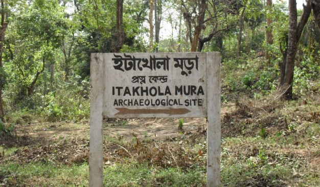
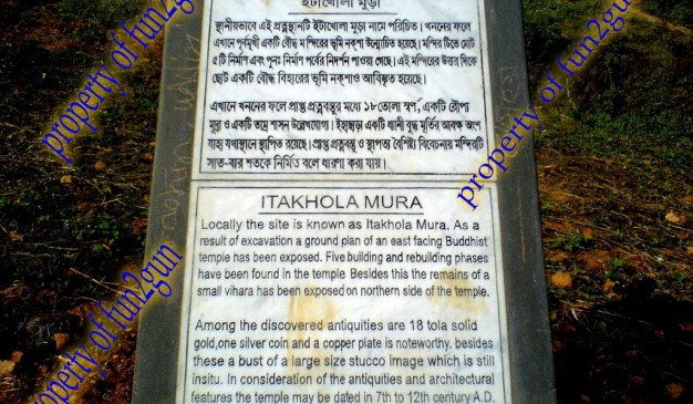
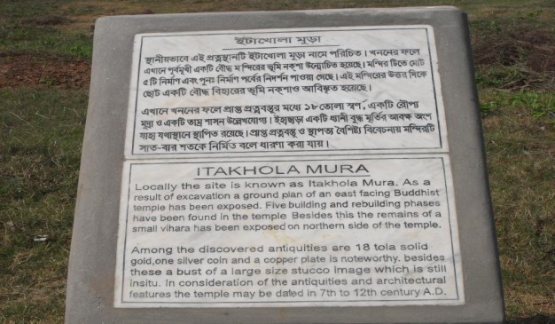
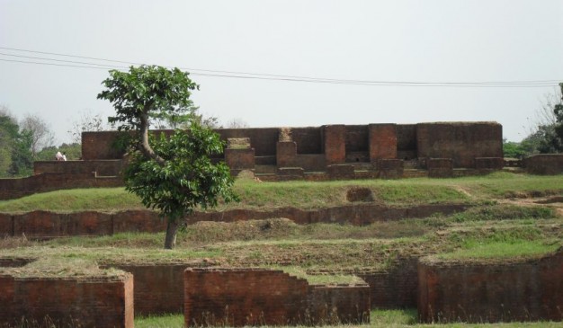
Itakhola Mura is an archaeological site in Mainamati. This site is one of the most impressive ruins. It lies in three terraces on adjacent hillocks just opposite the Rupban Mura site across the Kotbari road in Comilla. Excavations have revealed here a grand stupa complex with an attached monastery, located 42m to its north. The cultural phases of the site are stated (or overstated) to be five; the earlier three being still buried underneath the later remains.
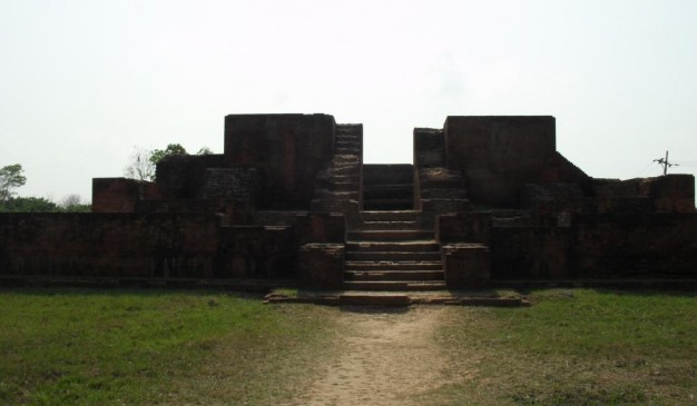
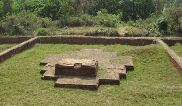
The Stupa Complex was originally built as a solid stupa in the traditional style on a 13.1 meter square basement. However, it has one peculiarity; a small sanctum (2.4 m x 2.1 m) built in the center of its eastern or front side.
Subsequently, the shrine was enlarged and elaborated by additions and alterations, especially by adding three long narrow chapels in the eastern side after blocking the old sanctum; thus giving the structure an oblong shape (41.4 m x 24m). In this particular feature, it is strikingly similar to the Rupban Mura shrine. The side chapels were ultimately blocked up, leaving space for a few cubicles for installing cult images, as in other parts of the shrine. This establishment is surrounded by a 2.6 m wide circumlocutory passage and is enclosed by a 1.2 m thick boundary wall.
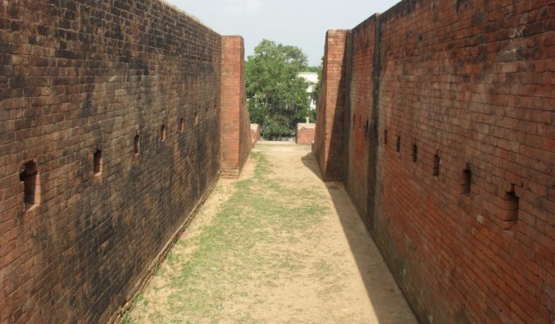
This holy precinct is again enclosed within a much larger, well-defined, and better preserved boundary wall (79 m x 56 m), in the slightly lower second terrace. It contains three interesting subsidiary shrines, two in two corners of the eastern side, and the other, a slightly larger one, at the back in the west. An elaborate entrance with 22 broad steps at the Center of the eastern side leads to the much lower third terrace. The outer face of its damaged boundary wall in this front side is excellently decorated with offsets, sunken panels, and ornamental designs.
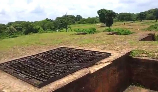
Five votive stupas lie at the base of the long staircase, three of them in a north south row within a well-defined enclosure, all semi-cruciform in shape, like that of the larger subsidiary shrines in the western side of the second terrace. They certainly represent an experimental early stage in the development of the cruciform style in Buddhist architecture that we see in mature form at shalvan vihara, paharpur, Vikramashila and many other sites. These structures may reasonably be dated as belonging to 7th-8th centuries AD.
The Monastery This medium sized monastery of the usual square shape with 19 cells and one entrance hall was built around an open courtyard, 16.2m. Square, on a separate mound. Its monumental gateway complex, 17.6m x 8.5m, projecting outwards, lies at the Centre of the eastern wing. Some of the cells have brick-built bedsteads. This structure was badly damaged by brick-hunters in 1944-45.
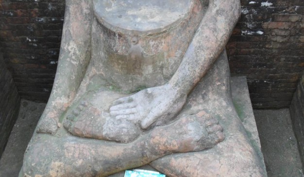
Mentionable antiquities from the site, besides the stucco image, are three round pellets of solid gold, (19 tolas), and a copperplate inscription, discovered during clearance work after the excavations. The copperplate has not yet been deciphered.
Array
(
[0] => Array
(
[name] => Chilla kotha
[post_id] => 11310
[post_link] => http://offroadbangladesh.com/bn/places/chilla-kotha/
[thumb_link] => http://offroadbangladesh.com/wp-content/uploads/2015/07/IMG_63031-300x225.jpg
[post_content] =>
Chilla kotha is a one storeyed rectangular shaped building which is locally known as Andhar kotha. There are three rooms existing inside the whole building. These rooms are almost same in dimension. The interesting thing is there is a secret room in the underground level, which is connected with a staircase to way out at the south-east corner of this building. The underground room is so dark as there is no ventilation system or window inside of it. There are some rectangular shaped panel outside the building.
The specific time period of this architecture is not known. Historians could dig the history as far as possible and from their review we got to know that the time period of Crori City of Panam Nogor and Chillakatha is the same.
Myth: Local people believes that it was being used as a meditation and praying place for different Muslim Saint & Sadhus. Specially, there is a belief among the local people that when some saints do their praying & meditation inside the Under ground room of this building then it was enlightened with a picture of Mekka Sharif. Some people also said that it was being used as a torcher cell for punishing people commited crime went against the rituals of Islam. In every year from the 25th of January a very local festival named ‘Oros sharif’ has been celebrated annually. Many people from different direction come to join this event.
Recently this building is almost being abandoned. The outer front side has been demolished and being decaying day by day. Necessary steps should be taken to conserve and preserve it for future generation.
)
[1] => Array
(
[name] => Panam Rajbari
[post_id] => 11576
[post_link] => http://offroadbangladesh.com/bn/places/panam-rajbari/
[thumb_link] => http://offroadbangladesh.com/wp-content/uploads/2015/07/SAM_01811-240x300.jpg
[post_content] =>
Poddar bari, or according to the local people, the "Panam Rajbari". This is a bit eastern side to the panam city. If someone wants to visit the place, then there is no way except passing through the panam city. This is currently a private property, and there is a picnic spot inside the boundary of the place. The owner of the place used to live at the newly built building beside the old one. But the old one is still empty.
After getting permission you can easily enter the area. Its not known when the building was actually built. But from the structure, and the design, it appears that it was built by some rich merchant during the 1900 AD. The structure and the design is almost identical to the Sonargaon Folk art and craft Museum. Inside the building, the yard is identical to the museum building of sonargaon.
The building comprises of numerous number of rooms. And interestingly you can move from one room to another one easily. There is no window at the rooms, and also no doors, most of those are taken down, or stolen, or something else. Since its a bit darker inside the building, its a hideout for the bats. When camera flashed, we have seen several bats were flying and making noisy sound. Also there nest of other birds which are making continuum sound, but we bet you won't feel bored by those. Those are really nice to hear. So if you are at sonargaon, please don't leave the place by only visiting the panam city. It will worth if you visit the place.
)
[2] => Array
(
[name] => {:en}Pailgaon Zamindar Bari{:}{:bn}পাইলগাঁও জমিদারবাড়ী{:}
[post_id] => 22961
[post_link] => http://offroadbangladesh.com/bn/places/pailgaon-zamindar-bari/
[thumb_link] => http://offroadbangladesh.com/wp-content/uploads/2015/11/P_20151014_130750_1_p-300x169.jpg
[post_content] => {:en}
Pailgaon Zamindar Bari is one of the remarkable old structures of Jagannathpur in Sunamganj. This 300 years old palace was established on 5.5 acres of land.
The last person of this Zamindar family was Brajendra Narayan Chowdhury. He was a famous politician at that time and a member of the congress of Sylhet too at that time.
The place is situated near the bank of Kushiara river in Sunamganj District. It is at Pailgaon Union under Jagannathpur Upazila.
History of this place: Thousand years ago, decedents of Pal Dynasty lived here. As time goes, "Das" family took their place. Pir Mohammad Badsha (Muslim Rulers) gave them the title - "Chowdhury". Ram and Sreeram were two descendants of this bloodline. One of their descendants Madhab Ram gained much popularity in his locality at that time. He did a lot of social welfare.
Their descendants Brojnath had two sons. Their named were Roshomoy Chowdhury and Sukhumoy Chowdhury. The place is locally known by the name after of Zamindar Roshomoy Chowdhury. The last ruler of the family was famous Brajendra Narayan Chowdhury.
{:}{:bn}প্রাচীন পুরাকীর্তির অন্যতম নিদর্শন সুনামগঞ্জের জগন্নাথপুর উপজেলার পাইলগাঁও জমিদারবাড়ী। প্রায় সাড়ে ৫ একর ভূমির ওপর প্রতিষ্ঠিত তিন শত বছরেরও বেশী পুরানো এ জমিদার বাড়ীটি এ অঞ্চলের ইতিহাস-ঐতিহ্যের নিদর্শন ।এ জমিদার পরিবারের শেষ জমিদার ব্রজেন্দ্র নারায়ণ চৌধু রী ছিলেন প্র খ্যাত শিক্ষাবিদ ও রাজনীতিবিদ। তিনি ছিলেন সিলেট বিভাগের কংগ্রেস সভাপতি এবং আসাম আইন পরিষদের সদস্য। সিলেট বিভাগের সুনামগঞ্জ জেলায় জগন্নাথপুর উপজেলার অধীন ৯ নম্বার পাইলগাও ইউনিয়নের পাইলগাও গ্রামে ঐতিহ্যবাহি এ জমিদারীর অবস্থান। জমিদার বাড়ী দক্ষিণ দিকে সিলেটের কুশিয়ারা নদী বহমান। প্রখ্যাত ঐতিহাসিক অচ্যূতচরণ চৌধুরী পাইলগাও জমিদার বংশের রসময় বা রাসমোহন চৌধুরী হতে প্রাপ্ত সূত্রেলিখেছেন যে; পাইলগাওয়ে বহুপূর্বকালে পাল বংশীয় লোক বসবাস করত। এ গোষ্টিয় পদ্মলোচন নামক ব্যক্তির এক কন্যার নাম ছিল রোহিণী। কোন এক কারণে রাঢ দেশের মঙ্গলকোট হতে আগত গৌতম গোত্রীয় কানাইলাল ধর রোহিণীকে বিবাহ করত গৃহ-জামাতা হয়ে এখানেই বসবাস শুরুকরেন। কানাইলাল ধরের আট পুরুষ পরে বালক দাস নামের এক ব্যক্তির উদ্ভব হয়। এ বালক দাস থেকে এ বংশ বিস্তৃত হয়। বালক দাসের কয়েক পুরুষ পর উমানন্দ ধর ওরফে বিনোদ রায় দিল-ীর মোহাম্মদ শাহ বাদশা কর্তৃ ক চৌধুরী সনদ প্রাপ্তহন। বিনোদ রায়ের মাধব রাম ও শ্রীরাম নামে দুই পুত্রের জন্মহয়। তার মধ্যেমাধব রামজনহিতকর কর্মপালনে নিজ গ্রাম পাইলগাঁও এ এক বিরাট দীঘি খনন করে সুনাম অর্জন করেন। তার দেয়া উক্তদীঘি আজও ঐ অঞ্চলে মাধব রামের তালাব হিসেবে পরিচিতহচ্ছে। মাধব রামের দুই পুত্র মদনরাম ও মোহনরাম । উক্ত মোহনরামের ঘরে দুর্লভরাম, রামজীবন, হুলাসরাম ও যোগজীবন নামে চার পুত্রের জন্ম হয়। এই চার ভাই দশসনা বন্দোবস্তের সময় কিসমত আতুয়াজানের ১থেকে ৪ নং তালুকের যতাক্রমে বন্দোবস্তগ্রহন করে তালুকদার নাম ধারণ করে। এদের মধ্যে হুলাসরাম বানিয়াচং রাজ্যের দেওয়ানি কার্যালয়ে উচ্চ পদের কর্মচারীনিযুক্ত হন। হুলাসরাম চৌধুরী বানিয়াচং রাজ্যের রাজা দেওযান উমেদ রাজারঅনুগ্রহে আতুয়াজান পরগণায় কিছু ভূমি দান প্রাপ্তহন। হুলাসরামের প্রাপ্তভূমির কিছু কিছু চাষযোগ্যও কিছু ভূমি চাষ অযোগ্যছিল। পরবর্তিতে হুলাসরাম চাষ অযোগ্য ভূমিগুলোকে চাষযোগ্যকরে তুললে এগুলোই এক বিরাট জমিদারীতে পরিণত হয়ে উঠে। হুলাস রামের ভাতুষ্পুত্রবিজয়নারায়ণের একমাত্রপুত্রব্র জনাথ চৌধুরীজমিদারি বর্ধিত করে এক প্রভাবশালী জমিদারে পরিণত হন। ব্রজনাথ চৌধুরীর দুইপুত্ররসময় ও সুখময় চৌধুরী। রসময় চৌধুরীর পুত্র ব্রজেন্দ্রনারায়নই ছিলেন এবংশের শেষ জমিদার।{:}
)
[3] => Array
(
[name] => {:en}Parulia Mosque{:}{:bn}পারুলিয়া মসজিদ{:}
[post_id] => 4137
[post_link] => http://offroadbangladesh.com/bn/places/parulia-mosque/
[thumb_link] => http://offroadbangladesh.com/wp-content/uploads/2015/03/DSCN1052-300x225.jpg
[post_content] => {:en}
Parulia Mosque,According to a Persy inscription attached in the main gateway of the mosque; Bibi Jainab, a daughter of Nasir shah and wife of Diwan Sharif, built this mosque in 1126 AH/ 1714 AD. Internally,it is 18.29m in long, 5.18m wide and the wall of the mosque is 1.52m thick. Two lateral arches divided the interior of the mosque into three square sections. Three domes cover the roof of these three sections. The domes are crowned with lotus and kalasa finials. There are banded octagonal corner towers at four corners of the mosque. It was an exception that all the corner towers reached up to the cornice. In the Mughal style corner towers generally reach above the cornice.
There are five archways in the mosque, three at the eastern wall and one each at northern and southern walls. The central archway is bigger than the other four which are all in same size and shape. The upper portion of the outer side of the main gateway is under a half-domed roof and is recessed in a rectangular structure. Three mihrabs are at the western wall corresponding to the three archways of the eastern wall. All the mihrabs and the archways are stuck in rectangular structure, which are ornamented with merlons. There are arched niches on both sides of the mihrabs and archways. Archways and mihrabs are marked by their outward projection. Rectangular and square panels decoration are in both sides of the outer face of the archways.
The mosque was partially damaged by earthquakes in 1897 and was renovated later on. There is a square shaped open courtyard in front of the mosque, which is surrounded by a wall not very high. A beautiful gateway is in the eastern side of this wall.
There are two ponds at the northern and southern side of the Mosque which has increased the beauty of Mosque. And it makes the environment of Mosque Premises cool.
There is a one domed square tomb of Diwan Sharif and Bibi Jainab on the western side of the mosque. Every year at some particular month many people of cultural diversity have come here to celebrate a fair (Local term oros). They open so many itinerant shop of snacks and different kinds of toys. People come to pray and wish to have something (Spiritual) which is related with the well being of their life.
{:}{:bn}
নরসিংদী জেলার পলাশ উপজেলার পারুলিয়ায় এই মসজিদটি অবস্থিত। মসজিদের মূল ফটকে রক্ষিত একটি পারস্য শিলালিপি থেকে জানা যায় ১১২৬ হিজরী/১৭১৪ সালে জনৈক নাসির নামক ব্যাক্তির কন্যা এবং দিওয়ান শরীফ নামক ব্যাক্তির স্ত্রী বিবি জয়নাব এই মসজিদটি নির্মাণ করেন। মসজিদটির অভ্যন্তরের দৈর্ঘ্য ১৮.২৯ মিটার, প্রস্থ ৫.১৮ মিটার এবং মসজিদের দেয়ালের ঘনত্ব ১.৫২ মিটার। দুটি ধনুকআকৃতির সমান্তরাল পথের মাধ্যমে মসজিদের অভ্যন্তরকে তিনটি বর্গাকারভাগে ভাগ করা হয়েছে। প্রতিটি ভাগের উপরেই একটি করে গম্বুজ রয়েছে। প্রতিটি গম্বুজে নকশা ও অলংকার খোদাই করা আছে। ব্যাতিক্রম হিসেবে মসজিদের চারকোণায় অষ্টভুজ টাওয়ার রয়েছে যেগুলোর প্রতিটির উচ্চতা কার্নিশ পর্যন্ত। মুঘল স্থাপত্যশৈলীতে কোনার টাওয়ারগুলোর উচ্চতা সাধারণত কার্নিশকে ছাড়িয়ে যায়। মসজিদটির মোট পাঁচটি ধনুকআকৃতির ফটকের মধ্যে পূর্বদিকের দেয়ালে তিনটি, উত্তর ও দক্ষিন দিকের দেয়ালে একটি ফটক রয়েছে। মসজিদের মাঝখানের ফটকটি অন্যান্য ফটকের চেয়ে বড়। মসজিদের মূল ফটকের বাইরের দিকটি উপরিভাগ অর্ধগম্বুজ আকৃতির ছাদের নীচে অবস্থিত যেটি একটি আয়াতক্ষেত্রাকার কাঠামোর উপর নির্মাণ করা হয়েছে। অন্যান্য ফটকগুলো সামান্য নিচু আয়াতক্ষেত্রাকার কাঠামোর উপর নির্মাণ করা হয়েছে। মসজিদের পশ্চিমদিকের দেয়ালে পূর্বদিকের ফটকগুলো বরাবর তিনটি মিহরাব অবস্থিত। সবকটি মিহরাব এবং ধনুকআকৃতির ফটকগুলো অলংকারখচিত আয়াতক্ষেত্রাকার কাঠামোর উপর নির্মাণ করা হয়েছে। মিহরাব এবং ফটকের উভয়দিকেই ধনুকআকৃতির কোটর রয়েছে। ফটকগুলোর বাইরের অংশে বর্গাক্ষেত্রাকার এবং আয়াতক্ষেত্রাকার নকশা রয়েছে। ১৮৯৭ সালের ভুমিকম্পে মসজিদটি আংশিক ক্ষতিগ্রস্ত হলেও পরবর্তীতে মসজিদটি মেরামত করা হয়। মসজিদের সামনের বর্গাক্ষেত্রাকার আঙ্গিনাটি প্রাচীর দিয়ে ঘেরা। তবে প্রাচীরের উচ্চতা খুব বেশি নয় তবে প্রাচীরের পূর্বদিকেএকটি চমৎকার ফটক রয়েছে।পারুলিয়া মসজিদের উত্তর ও দক্ষিণদিকে অবস্থিত দুটি পুকুর মসজিদ অঙ্গনকে ঠাণ্ডা রাখার পাশাপাশি মসজিদের সৌন্দর্য বহুগুনে বৃদ্ধি করেছে।
মসজিদের পশ্চিমে দিওয়ান শরীফ এবং বিবি জয়নাবের এক গম্বুজবিশিষ্ট দরগা অবস্থিত। প্রতিবছর এখানে বছরের একটি নির্দিষ্ট মাসে মেলা (স্থানীয়ভাবে ওরশ বলা হয়) অনুষ্ঠিত হয় যেখানে বিভিন্ন সংস্কৃতির মানুষজন অংশ নিয়ে থাকে। এসময় এখানে বিভিন্ন খাবার ও খেলনা পাওয়া যায়। মানুষ এখানে এসে প্রার্থনা করে এবং নিজেদের জীবনের সমৃদ্ধির জন্য কিছু চেয়ে থাকে।
{:}
)
)