Brief
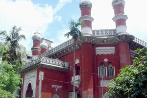
নর্থব্রুক হল একটি ইন্দো-সারাসেন ভবন যেখানে মুঘল এবং ইউরোপিয়ান রেনেসার স্থাপত্যশৈলীর সংমিশ্রণ লক্ষ্য করা যায়। লালকুঠির উত্তরদিকের প্রবেশপথে রয়েছে অর্ধগোলাকার ঘোড়ার পায়ের নালের আকৃতির তোরণ। ভবনটির উত্তর দিকে অবস্থিত চারটি অষ্টকোন বিশিষ্ট মিনার, ছাদে অবস্থিত সজ্জিত তীক্ষ্ণ চূড়া এবং নকশা করা পাচিল থেকে মুসলিম ও মুঘলদের বৈশিষ্ট্য লক্ষ্য করা যায়। ভবনটির দরজা, জানালা এবং দেয়ালের নকশা ইউরোপিয়ান কায়দায় করা হলেও ভবনের গম্বুজের নকশা করা হয়েছে মুসলিম স্থাপত্যের সাথে মিল রেখে।
১৮৭৪ সালে ভারতের গভর্নর থমাস জর্জ ব্যারিং এবং (১৮৭২ সাল থেকে ১৮৭৬ সাল পর্যন্ত) নিযুক্ত ভাইসরয় লর্ড নর্থব্রুক ঢাকায় এসেছিলেন। তাঁদের ঢাকা সফরকে স্মরণীয় রাখতে রাজা রায়বাহাদুর, অন্যান্য জমিদারেরা এবং বিশিষ্ট নাগরিকরা প্রত্যেকে পাঁচ হাজার টাকা থেকে দশ হাজার টাকা পর্যন্ত অনুদান প্রদান করেন টাউন হল নির্মাণের জন্য ১৮৭৯ সালে। অভয় চন্দ্র দাস ছিলেন কমিটির সচিব। ১৮৮০ সালে ঢাকার কমিশনার এই টাউন হলের উদ্বোধন করেন। সেসময় নবাব আব্দুল গনির অর্কেস্ট্রাকে নিয়ে আসা হয়েছিল উদ্বোধন উপলক্ষে আগত কমিশনার এবং আগত অতিথিদের আনন্দ দেওয়ার জন্য।
১৮৮২ সালের ৮ই ফেব্রুয়ারি হলের দক্ষিন-পূর্বদিকে নর্থব্রুক পাবলিক লাইব্রেরি নামে একটি পাঠাগার যুক্ত করা হয়। সুবিশাল সংগ্রহের জন্য পাঠাগারটি অল্প সময়েই সুনাম অর্জন করে। ১৯৭১ সালের মুক্তিযুদ্ধের সময় পাঠাগারের অনেক বই ধ্বংসপ্রাপ্ত হয়। পাঠাগারটি পুনঃপ্রতিষ্ঠার জন্য ত্রিপুরার মহারাজা ১০০০/- টাকা, বালিয়াতির জমিদার ব্রজেন্দ্র কুমার রায় ১০০০/- টাকা, রানী স্বর্ণময়ী ৭০০/- টাকা, কালীকৃষ্ণ ৫০০/- টাকা এবং বিশাশিশ্বরি দেবী ৫০০/- টাকা অনুদান করেন। ১9৮৭ সালে পাঠাগারটি ১০০০ বইসহ আবার চালু করা হয়।
জনসন হল নামে একটি ক্লাব হাউস লালকুঠির দক্ষিন দিকে যুক্ত করা হয়। নর্থব্রুক হলে নোবেল বিজয়ী কবি রবীন্দ্রনাথ ঠাকুরকে সংবর্ধনা দিয়েছিল ঢাকা মিউনিসিপালিটি এবং পিপলস এসোসিয়েশন ১৯২৬ সালের ৭ই ফেব্রুয়ারি। ১৯৫০ সালে নর্থব্রুক হলকে পোস্ট অফিস হিসেবে ব্যবহার করা হয় এবং পরবর্তীতে এটি কেন্দ্রীয় মহিলা কলেজ হিসেবে ব্যবহৃত হয়। বর্তমানে এই ভবনটি ঢাকা মিউনিসিপালিটি কর্পোরেশনের সম্পত্তি।
নির্মাণের পর নর্থব্রুক হল থেকে বুড়িগঙ্গা নদী দেখা যেতো। তবে ১৯৩০ সালের মধ্যে এখান থেকে নদী দেখার পথ রুদ্ধ হয়ে যায়। ধীরে ধীরে এলাকাটি গুরুত্ব এবং আবাসিক ধরন হারিয়ে ফেলে এবং বাণিজ্যিক এলাকায় পরিণত হয়। ১৯৯৮ সালে নর্থব্রুক হলের পাশে সরকারের শিক্ষা বিভাগের কার্যালয় প্রতিষ্ঠা করা হয় যেটির একাংশ বর্তমানে একটি ডেকোরেটোর সেবা প্রদানকারী সংস্থা ব্যবহার করছে। এছাড়া হলের উত্তরদিকের প্রবেশমুখে একটি পঞ্চভুজ ঝর্ণা স্থাপনের ফলে ভবনটি একেবারেই দৃষ্টিগোচর হয়না।
প্রত্নতত্ত্ব অধিদফতরের সংরক্ষণ করা অন্যতম ভবন হল এই নর্থব্রুক হল। বিগত কয়েক বছরে প্রত্নতত্ত্ব অধিদফতর ও ঢাকা মিউনিসিপালিটি যৌথভাবে স্থানীয়দের সাথে নিয়ে ভবনটির সংস্কার করেছে। যেহেতু ভবনটি প্রায় শতবর্ষ ধরে একটানা ব্যবহার হয়ে আসছে তাই এটির মূল কারুকাজ এবং ফ্লোরের নকশা বেশ ভাল অবস্থায় আছে। এছাড়া অন্যান্য ঝুঁকিপূর্ণ ঐতিহ্যের তুলনায় এই ভবনটি বেশ ভাল অবস্থায় আছে এবং এটির রক্ষনাবেক্ষনে পৃথক কোন তহবিলেরও প্রয়োজন হয়নি (যেমনটি পানামনগরের ক্ষেত্রে দেখা গিয়েছে)।
প্রত্নতত্ত্ব অধিদফতরের তত্ত্বাবধানে ভবন ব্যবহারকারীরা নিজেরাই ছোটখাটো মেরামতের দায়িত্ব গ্রহন করেছে। নর্থব্রুক হল সংরক্ষণকে বলা যেতে পারে প্রত্নতত্ত্ব অধিদফতরের অন্যতম সাফল্য।
তবে, ঐতিহ্যবাহী এই ভবনটির জন্য বড় হুমকি হল এটির আশেপাশে গজিয়ে ওঠা বিভিন্ন স্থাপনা যেমন অ্যাসেম্বলি হল এবং কিছু কমিউনিটি সেন্টার। এছাড়া ২০০৯ সালে প্রকাশিত ‘সংরক্ষিত ঐতিহ্যের’ তালিকা নর্থব্রুক হলটি সংরক্ষণে অন্যতম গুরুত্বপূর্ণ ভুমিকা পালন করছে। এই তালিকাটি প্রকাশের পূর্বে ঢাকা মিউনিসিপাল কর্পোরেশন, প্রত্নতত্ত্ব অধিদফতর এবং স্থানীয়দের মধ্যে সমন্বয়হীনতা ছিল। তালিকাটি প্রকাশের মাধ্যমে নর্থব্রুক হলের সংরক্ষণ ত্বরান্বিত হয়েছে।
Array
(
[0] => Array
(
[name] => {:en}Rubber Dam{:}{:bn}রাবার ড্যাম{:}
[post_id] => 5599
[post_link] => http://offroadbangladesh.com/bn/places/rubber-dam/
[thumb_link] => http://offroadbangladesh.com/wp-content/uploads/2015/03/Rubber-Dam1-300x191.jpg
[post_content] => {:en}
Rubber Dam is another beautiful place in Cox’s Bazar. Since Bangladesh has very little rainfall in the winter, the requirement of water for irrigation during the season is met from ground water sources and by conserving a part of the monsoon surface water. To do this, the Local Government Engineering Department in Bangladesh has introduced rubber dams, a cost effective technology that retains and conserves surface water in the river channel, reservoirs and lakes. It has constructed two pilot rubber dams in the Bakkhali River and Idagaon Khal in Cox’s Bazar district that would supply irrigation water to 8,000 hectares for rice cultivation.
[We need more detail information of this spot. If you have more information and photos, please be advised to add and share in our website. Your name will be published as a Content Contributor]
{:}{:bn}
রাবারের বাঁধ হল কক্সবাজারের আরেকটি দর্শনীয় স্থান। শীতকালে বাংলাদেশে বৃষ্টিপাত কম হওয়ায় এসময়ে জমি চাষের জন্য পানির চাহিদা পুরন করা হয় ভু গর্ভে জমে থাকা পানি এবং বর্ষাকালে জমানো বৃষ্টির পানি থেকে। এ কারনে বাংলাদেশের স্থানীয় সরকার প্রকৌশল অধিদফতর ভু গর্ভে জমে থাকা পানি বিভিন্ন নদীর চ্যানেল, লেক ও রিজার্ভারে সংরক্ষণের জন্য স্বল্প খরচে একটি প্রযুক্তি চালু করেছে। এই উদ্দেশ্যে কক্সবাজার জেলার বাকখালি নদী এবং ঈদগাঁও খালে পরীক্ষামূলকভাবে দুটি রাবারের বাঁধ নির্মাণ করা হয়েছে যার মাধ্যমে ধান চাষের জন্য প্রায় ৮০০০ হেক্টর জমিতে সেচের পানি সরবরাহ করা হবে।
{:}
)
[1] => Array
(
[name] => {:en}Government Buffalo Farm{:}{:bn}মহিষের খামার{:}
[post_id] => 6536
[post_link] => http://offroadbangladesh.com/bn/places/government-buffalo-farm/
[thumb_link] => http://offroadbangladesh.com/wp-content/uploads/2015/04/Mohisher-Khamar-buffalo-farm-011-300x226.jpg
[post_content] => {:en}
Government Buffalo Farm in Bangladesh was started by the government at 1984 for the better reproduction of buffalo. Also they had a plan to supply the hybrid buffalo to the farmers in a low cost, so that they can use that for plowing the land. But similar to many other government's concerns, this project also never got enlightened latter. It is a vast area and one side is bounded by a canal or river. It has a very wide open field inside (for grazing).
[This spot needs more detail. If you have more information and photos, please be advised to add in our website. Your name will be published as a Content Contributor]
{:}{:bn}
মহিষের উন্নত বংশবৃদ্ধির লক্ষ্যে সরকার ১৯৮৪ সালে মহিষের খামার চালু করে। হাইব্রিড জাতের মহিষ উৎপাদন এবং কৃষকের কাছে এসব মহিষ স্বল্প দামে পৌঁছে দেওয়াও ছিল এই খামার চালুর উদ্দেশ্য যাতে করে কৃষকরা এসব মহিষ হালচাষের কাজে ব্যবহার করতে পারে। বিশাল এলাকার উপর অবস্থিত এই খামারের এক প্রান্তে নদী রয়েছে এবং খামারের অভ্যন্তরে গোচারনভূমি হিসেবে ব্যবহারের জন্য প্রশস্ত বিশাল মাঠ রয়েছে।
{:}
)
[2] => Array
(
[name] => Teesta Railway Bridge
[post_id] => 6434
[post_link] => http://offroadbangladesh.com/bn/places/teesta-railway-bridge/
[thumb_link] => http://offroadbangladesh.com/wp-content/uploads/2015/04/tista-barrage1-300x200.jpg
[post_content] =>
Teesta Railway Bridge is the third largest railway bridge of the country lengths about 2000 feet and constructed in the year 1834.
In 1978, to manage load of road vehicles for Lalmonirhat, Kurigram and beyond by ferry, the then president Ziaur Rahman instructed the Railway and Roads authority to set wooden sleepers in the rail bridge between the rails for all types of vehicular movement. Same year, March 4, President Ziaur Rahman inaugurated the bridge for vehicular movement. The bridge restores the communication from divisional headquarters of Rangpur with two districts, Lalmonirhat and Kurigram.
The bridge is now in broken-down condition and needs major repair. For motor vehicles construction of a road bridge began next to it in 2006 for completion by 2009 at a cost of Tk 1.22 billion which is now expected to be opened in June 2012.
)
[3] => Array
(
[name] => The Central Cooperative Bank
[post_id] => 15727
[post_link] => http://offroadbangladesh.com/bn/places/the-central-cooperative-bank-2/
[thumb_link] => http://offroadbangladesh.com/wp-content/uploads/2015/08/The-Central-Cooperative-Bank10-300x225.jpg
[post_content] =>
The Central Cooperative Bank was established in 1921 during the British Period, under the then British Lord [Lawrence John Lumley Dundas, 2nd Marquess of Zetland]. All the transactions of his area where held and maintained by this bank. From the architectural point of view, undoubtedly this building holds the year old history. It is considered to be the oldest bank in Natore region. The foundation of the bank was laid by The Honorable Nawab Saiyed Nawab Ali Chowdhury Khan Bahadur C. I. E. on 15th February 1921.
The condition of this building is not good, as this years old structure has not been renovated yet and remain forsaken or excluded. Also, the government has not been any precautions to preserve this building. Now, it is being using by local people for some other purposes. The local government authority should take steps to save this historical attraction.
)
)