Naldanga Zamindar Bari
Type: Palace
Contributed By: Nayeem


Brief
Naldanga Zamindar Bari (নলডাঙ্গা জমিদার বাড়ি) is a very significant historical place of Gaibandha. It was the birth place of Tulshi Lahiri, a great artist, actor as well as writer. Surendrochandro, father of Tulshi Lahiri, decorated this colorful Zamindar Bari. Cheratar is one of the dramatic book of Tukshi Lahiri which is still included in books in the intermediate standard level in Kolkata.
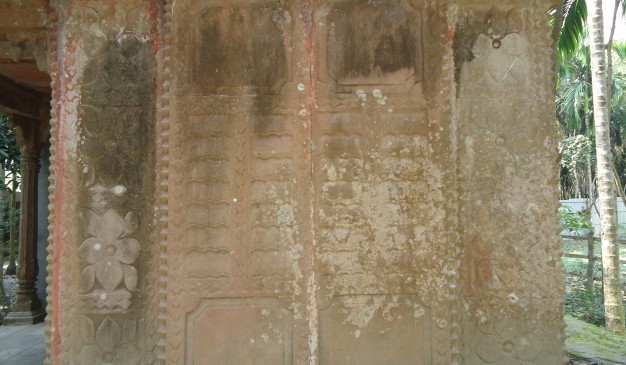
At British period, Naldanga Zamindar Bari was one of the vital center for collecting revenue of North Bengal. Shibchandra and Shomvochandra were the two brothers who first came to Naldanga and founded the Zamindar Bari. Shibchandra was the grandfather of Tulshi Lahiri. Back of the Zamindar Bari, a relics of Mandir is still seen here. In front of the wall of Zamindar Bari, many valuable sculptures had been hooked, but most of them were stolen or snatched by the local people. Only one sculpture was rescued and still unharmed.
How to go
First you have to reach Gaibandha. Then take a CNG to reach Tulshighat. Then hire a CNG for going to Sadullapur. At last you have to hire a CNG for going to Naldanga rail station. Naldanga Zamindar Bari is Just half kilometer away from Naldanga rail station.
How To Reach: Gaibandha District
Dhaka and Gaibandha is linked by road. You can take a bus from Dhaka to reach Gaibandha district. Some of the bus services have been listed below for your assistance.
1. S R Travels,
Counters:
Gabtoli, contact: 02-8011226,
Kollanpur, contact: 02-8013793, 01711-394801,
Abdullahpur, contact: 0171944023,
Uttara, contact: 01552315318
2. Shah Fathe Ali,
Moakhali, Contact: 01193-221 085,
Uttara, Contact: 01193-221 084
3. Alhamra Travels,
Gabtoli, Contact: 88-02-9005612, 01721-802 031
4. Alhamra Paribahan,
Gabtoli, phone : 02-9005612, mobile : 01721802031
5. SR Travels
Gabtoli, contact: 02-8011226
There is one intercity train available that has one stoppage station at Gaibandha. Necessary information of the train service has been given below for your assistance:
1. Lalmoni Express:
Train operates every day except Fridays.
It may take 8 hours 17 minutes to reach the destination.
Where to Stay
There are some notable hotels In Gaibandha. Some of the hotel services have been listed below for your assistance:
1. Hotel Al-Saiful
Shahid Suhrawardy Road,
Moddhopara, Gaibandha.
Mobile: 01962-615415, 01764-990822, Phone: 0541-62090
2. Hotel R-Rahman
Shaheed Anwar Hossen Sarak, Gaibandha
Phone: 0541-61481, Mobile: 01713-270283, 01715464748
3. Hotel Rajmahal,
DB road, bus stand, Gaibandha
Mobile: 01737805563
Things to do
1. If you visit the place you may gather experience about ancient architectural design of the Zamindar Bari of our country.
2. You may surprise how valuable historical place is located here without any protection.
Eating Facilities
The local food items of Sadullapur and Gobindaganj are the same. You can take the local delicious food items such as puri, jilapi, rashmalai (রসমালাই) etc. Referred to where to eat in Gaibandha, click here


