Brief
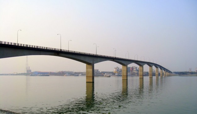
Official name of Meghna Bridge is Japan Bangladesh Friendship Bridge 1. It carries Motor vehicles and pedestrians. It is situated over the Meghna River. This bridge was designed by Cantilever bridge. The total length of the bridge is 900 meters (2,952 ft 9 inches), in width 9.2 meters (30 ft 2 inches). The longest span is 87 meters (285 ft 5 inches). It was opened for public in February 1, 1991. The coordinates is 23°36.162′N 90°36.991′E
Meghna Bridge is a road bridge in Bangladesh. It was built by assistance of Japan and officially named Japan Bangladesh Friendship Bridge 1, but it is popularly known as Meghna Bridge. According to a study conducted in 2004 by the Embassy of Japan in Bangladesh, residents living around the Meghna Bridge recognized several positive impacts after the construction of the bridge. In 2005, the bridge underwent extensive repair because the expansion joints of the bridge were damaged due to the lack of appropriate maintenance.
Architecture: Meghna Bridge is a cantilever and girder bridge. It is 930 meters (3,051 ft 2 in) in length with dual carriageway and 9.2 meters (30 ft 2 in) in width. The bridge has thirteen spans. Two among the individual spans are of 24.25 meters (79 ft 7 in) in length each, one is of 48.3 meters (158 ft 6 in) in length, nine spans are of 87 meters (285 ft 5 in) in length each and the length of the rest is 18.2 meters (59 ft 9 in). The carriage way of the bridge is 7.2 meters (23 ft 7 in). The foundations are supported on RCC caissons and piles. Piled foundation of abutments are buried. RCC caissons which are used as foundation under the piers are also buried. Both abutments and the piers of the bridge are RCC solid type. The piers of the bridge are hexagonal. Each pier is of 11 meters (36 ft 1 in) in length and 3.2 meters (10 ft 6 in) in width.
The wing walls of the bridge are of RCC and are fixed with abutments and have no weep holes. Railing type of the bridge is of R.C.C post and steel rail. The bridge has 0.80 meters (2 ft 7 in) wide sidewalk at both sides. Meghna Bridge also has infrastructure of drainage.
Economic impact: Traffic volumes across the Meghna River and of National Highway No. 1 significantly increased after the opening of the Meghna Bridge. In April 1997, an average of 10,149 vehicles of all types used the bridge in each 24 hours while March 2004 saw 9,704 vehicles per day. The reason behind this fall in traffic volume is attributed to increase in toll rate in 2002 and seasonal fluctuations. Below is a comparison of vehicles using the bridge per day in April 1997 and March 2004.
The survey conducted in 2004 by the Embassy of Japan in Bangladesh found that a majority of the users of the bridge believe that the construction of the Meghna Bridge improved the life of the people living near it and the surrounding area of the bridge has been urbanized. The people surveyed opined that the number of traffic blockage caused by bad weather has been decreased since the construction. The survey also found that 42% of the trucks using Meghna Bridge transport goods between Dhaka and Chittagong.
Array
(
[0] => Array
(
[name] => Puran Para Railway Bridge
[post_id] => 12173
[post_link] => http://offroadbangladesh.com/places/puran-para-railway-bridge/
[thumb_link] => http://offroadbangladesh.com/wp-content/uploads/2015/08/IMG_0554-300x200.jpg
[post_content] =>
Puran Para Railway bridge is located at puran para (পুরান পাড়া) area of Narsingdi Sadar. It is one of the renowned and popular public places in Narsingdi district for wondering around.
This place belongs a narrow road heading toward the river Arial Kha. This road is unique as it contains rows of green trees on its both side making its beauty far more natural and people of different ages use this road for their morning or evening walk.
Besides, if someone go ahead following this beautiful road then he/she will be ended up in the bank of river Arial kha and a newly constructed iron made railway bridge which is obviously a gorgeous one to visit recurrently.
)
[1] => Array
(
[name] => Lalon Shah Bridge
[post_id] => 2975
[post_link] => http://offroadbangladesh.com/places/lalon-shah-bridge/
[thumb_link] => http://offroadbangladesh.com/wp-content/uploads/2015/02/Lalon-Shah-Bridge-by-Mahmudur-Rahman-Khan-300x225.jpg
[post_content] =>
Lalon Shah Bridge (Bengali: লালন শাহ সেতু), also known as the Paksey Bridge, is a road bridge in Bangladesh over the river Padma, situated between Ishwardi Upazila of Pabna on the east, and Bheramara Upazila of Kushtia on the west. Named after early 19th century mystic poet Lalon Shah of Chhewuriya, Kushtia District, the bridge was completed in 2004.
The bridge is 1,800 metres (5,900 ft) long and is the fourth longest road bridge of the country, after Jamuna Bridge, Meghna Bridge and Meghna-Gomti bridge. It provides important road connection to Mongla port of Khulna District in the south from Rajshahi division and Rangpur division, the northern part of Bangladesh. It is situated parallel to and south (downstream) of Hardinge Bridge.
)
[2] => Array
(
[name] => Hardinge Bridge
[post_id] => 2871
[post_link] => http://offroadbangladesh.com/places/hardinge-bridge/
[thumb_link] => http://offroadbangladesh.com/wp-content/uploads/2015/02/Hardinge-Bridge-300x146.jpg
[post_content] =>
Hardinge Bridge (Bengali:
হার্ডিঞ্জ ব্রিজ) is a steel railway bridge over the river Padma located at Paksey in western Bangladesh. It is named after Lord Hardinge, who was the Viceroy of India from 1910 to 1916. The bridge is 1.8 kilometers (1.1 mi) long. It is named after Lord Hardinge. From 1910-1916 he was the Viceroy of India. Its construction began in 1910 and ended in 1912, though it was proposed two decades ago. There was train movement on it from 1915. There was proposal of constructing a railway bridge over Padma. Eastern Bengal Railway laid the proposal in 1889.The motive of constructing this bridge was to ease communication between Eastern part of Bengal and Kolkata.
The construction of a railway bridge over the Padma was proposed in 1889 by the Eastern Bengal Railway for easier communication between Calcutta and the then Eastern Bengal and Assam. In 1902, Sir FJE Spring prepared a report on the bridge. A technical committee reported that a bridge could be constructed at Sara crossing the lowerGanges between the Paksey and Bheramara Upazila stations on the broad gauge railway from Khulna to Parbatipur Upazila. The construction of the bridge started in 1910 and finished two years later. The bridge comprises 15 steel trusses. The main girders are modified "Petit" type.
The most difficult task of the operation was to prevent bank erosion and to make the river flow permanently under the bridge. For this, two guide banks of the "Bell-bund" type named after J. R. Bell were built on either side, each extending 910 metres (3,000 ft) upstream and 300 metres (1,000 ft) downstream from the bridge.
[2] The ends of the river banks were curved inward and heavily pitched with stone.
Hardinge Bridge was severely damaged during the Liberation War of Bangladesh of 1971. It happened on 13 December 1971, when the Indian Air Force plane bombed on the 4th guarder from the Paksey side. As the Pakistani army was on retreat towards Jessore (their last stronghold) Hardinge Bridge was strategically very important. The allied force damaged the bridge. The Japanese Government helped to reconstruct the bridge. It is the second largest railway bridge in Bangladesh. Another bridge named Lalon Shah Bridge for road transport beside the Hardinge Bridge has recently been constructed.
)
[3] => Array
(
[name] => Mirkadim Bridge
[post_id] => 8217
[post_link] => http://offroadbangladesh.com/places/mirkadim-bridge/
[thumb_link] => http://offroadbangladesh.com/wp-content/uploads/2015/05/Mirkadim-Bridge-11-300x200.jpg
[post_content] =>
Mirkadim bridge (মীরকাদিম ব্রিজ) spans the Mir Kadim canal (creek) which runs from Mir Kadim to Tangibari. It connects the village Abdullahpur and Panam area of Rampal Union Parishad under Munshigonj District. It is situated at a distance of about 5.50 km from the district headquarters. The local tradition claims it to have been built by King Ballal Sen, but the architectural features belie the local tradition. The bridge can architecturally be attributed to the Mughal period, not earlier than 17th century. The 53m long bridge consists of a central pointed arch of 4.40m span with two side arches of 2.25m span each. The central arch is 0.40m high from the water level of the creek and at present 31m wide. It is 6.15m wide with each wing measuring 16.80m in length. The central arch is flanked by an octagonal pilaster on each side. Similarly each of the side arches has a pilaster each crowned with a cupola. The plasters of the side arches rise above the spandrel of the arch but those of the central arch are shorter and so not reach the archivolt. The pier is 1.85m thick. It is reported that on either end of the bridge there were circular pillars but now these are buried under earth. It appears that there are 6 piers on each side of the bridge. The central arch is loftier and wider than the side ones and is set in a deep rectangular panel with plain plastered spandrel. Base of the arches provided with cut waters. The hump backed bridge rises to a central point from which its back gently slopes to either side. It has a 70 cm high parapet wall on either side. The surviving thickness of the bridge measures 4.34m.
It has been protected and repaired extensively by the Department of Archaeology.
)
)