Array
(
[0] => Array
(
[name] => House of Mithu Kalu Bepari
[post_id] => 10739
[post_link] => http://offroadbangladesh.com/places/house-of-mithu-kalu-bepari/
[thumb_link] => http://offroadbangladesh.com/wp-content/uploads/2015/07/IMG_20150527_150048194-300x169.jpg
[post_content] =>
House of Mithu Kalu Bepari, About 150 years old house, is located near to the Sonarong Jora Moth at Tongibari Upazila of Munshiganj District. It was built by a renowned Merchant named Mithu Kalu Bepari. This old house is abandoned now. It is being used as store house for reserving fire woods.
[We need more detail information of this spot. If you have more information, then please be advised to add and share in our website. Your name will be published as a Content Contributor]
)
[1] => Array
(
[name] => Bikrompur Bouddha Bihar
[post_id] => 8281
[post_link] => http://offroadbangladesh.com/places/bikrompur-bouddha-bihar/
[thumb_link] => http://offroadbangladesh.com/wp-content/uploads/2015/05/bb-1-300x169.jpg
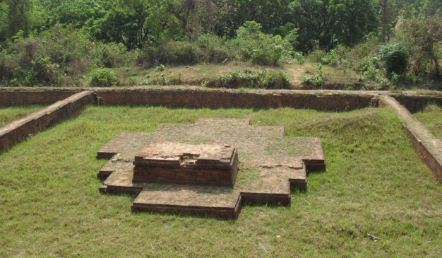
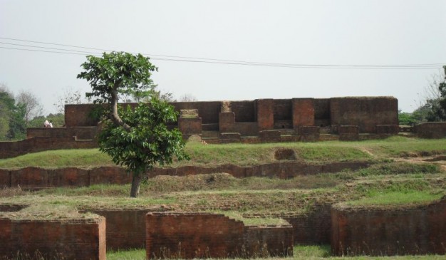
[post_content] => Bikrompur Bouddha Bihar(বিক্রমপুর বৌদ্ধ বিহার) is one of the most ancient Buddhist Bihar (Approximately 1000 years old), buried under soil at Rampal union parishad of Raghurampur Village in Munshiganj District. It is assumed that this Bihar was built in late 8th-9th century AD. It was revealed by conducting excavation very recent years. Bihar is a place being used as a Residential Higher Education Center.
How it was discovered: Researchers said, from the very beginning they had conducted nine test excavations at Rampal & Bojrojogini Union Parishad, where they found the evidences of pre-medieval human settlement. At the 9th grid they discovered the existence of a brick wall. Depending on that evidence Archaeologist dug a trench measuring 80×60m. Later they discovered this Buddhist Bihar.
What can be seen there: In the south-east corner of that structure there are two diagonal brick walls. One is extended from south to north and another one is extended from east to west. Likewise, the other Buddhist Bihar structure the chamber for Buddhist Monk was built beside main brick wall. In the northern side there are five chambers have been revealed. Near to the western there is a another chamber. Dimension of those chambers are nearly three square meter. The side wall dividing the chambers is also being discovered.
Observing the architectural strategy and characteristics, researchers had confirmed this feature as a Buddhist Bihar. Similarity had been found in architectural property and design with the Shompur Bihar (Naogaon), Mahasthangarh (Bogra), Shalbon Bihar ( Comilla) and even with Nalonda Bihar of Patna (India). A pancha-stupa (Five stupa) structure is also been discovered at the middle of that Bihar.
)
[2] => Array
(
[name] => {:en}Wari Bateshwar{:}{:bn}উয়ারি-বটেশ্বর{:}
[post_id] => 4083
[post_link] => http://offroadbangladesh.com/places/wari-bateshwar/
[thumb_link] => http://offroadbangladesh.com/wp-content/uploads/2015/03/23331-300x190.jpg
[post_content] => {:en}
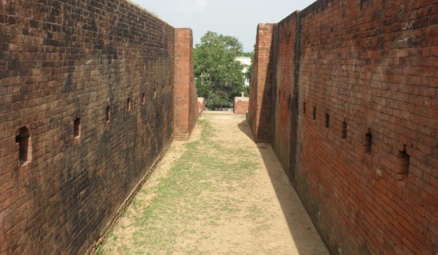
A two thousand five hundred year old fort-city was discovered at Wari-Bateshwar, after extensive exploration and limited excavation. In the 600m depth there is a fortified enclosure and four mud ramparts. Though most of the parts of the ancient ramparts have been destroyed but evidence of 5-7 feet height walls still exist in some places. The ramparts are surrounded by moat, which, in course of time, silted up and turned into paddy fields.
In the west and south-west side of Wari-Bateshwar citadel, there is a 5.8 km long, 20m wide and 10 m high mud rampart known as Asom Razar Garh. So far there are 50 archaeological sites have been discovered situated maintaining some specific distance and Wair-Bateshwar fort-city located by the bank of the river old Brahmaputra.
It is an evidence from the pattern of the archaeological sites that the ancient people established their settlements in flood-free zone. This is also the evidence of the knowledge of urban planning and intellectual capability of the ancient settlers. Similar settlement patterns we can find at Mahasthangarh (Pundranagar) in Bogra and Allahabad region of Uttar Pradesh, India. In the region of Wari-Bateshwar ,rest of the discovered archaeological sites have been buried under soil. It is assumed that they dwellers of this area used to live by agriculture and their surplus food productions were used to fulfill the necessity of the businessmen, priest and royal officials - those who lived in the city.
From the series of excavation at Wari-Bateshwar there have been several Buddha monastery, ancient lotus temple, Buddhist temple and Reversed pyramid features etc. are discovered in the recent years. But, now all have been buried again for temporary conservation.
The ancient inhabitants of this region were familiar with improved technical knowledge. By cutting the stone, they could manufacture beads. Raw materials, chips and flakes of semi-precious stone bead manufacture have been discovered during excavation. Which proves that there might be a big manufacturing company of beads & amulets. Through using different types of chemicals, they could decorate the beads.
They could also coat the northern black polished ware (NBPW) by using different chemicals. Developed technology was being used to control the temperature during pottery manufacture. They knew the techniques and methods of coin manufacturing by melting metal. They had the knowledge of iron processing too.
The location of Wari-Bateshwar fort-city and Asom Rajar Garh prove that, the inhabitants were experts in geometric knowledge. These factors indicate the ancient inhabitants’ close acquaintance with technological and scientific knowledge as well evidently indicate their artistic sense, adoration of beauty and skills in several technological works. Northern Black Polished Ware has a close relationship with urban culture.
Generally northern black polished wares are found in the archaeological sites of the second urbanization of the subcontinent. It is said that to meet the practical needs of the rulers and traders of the second urbanization, these northern black polished wares were produced. For the presence of Old Brahmaputra river channel, it is assumed that Wari-Bateshwar was a river port and a trade Centre as well.
From the discovery of semi-precious stone beads made of agate, quartz, jasper, carnelian, amethyst, chalcedony etc. Dilip Kumar Chakraborti (professor, South Asian Archaeology, Cambridge University) mentions that Wari-Bateshwar might be the ‘Souanagoura’ a trading centre which was mentioned by Ptolemy (2nd century geographer).
Sandwich glass bead, Rouletted Ware, knobbed ware, NBPW , different beads, amulets and pendants etc. confirmed that Wari-Bateshwar had a close connection with the contemporary several places of Indian subcontinent. It is also assumed that outside Indian subcontinent, Wari-Bateshwar had relations with South-east Asia and the Mediterranean also. In the Buddhist source Jataka and other ancient literature mentioned about the contact between Indian subcontinent and the South-east Asia.
In Wari-Bateshwar the most important discovery of the chalcolithic culture is black and red ware and evidence of pit-dwelling. Several evidence of pit-dwelling has been discovered at Inamgaon, Maharashtra, India. Ethno archaeological research shows that at Inamgaon, pit-dwelling culture still exist there. However, though Pit-dwelling of semi-arid Inamgaon has been discovered, the pit dwelling of Wari-Bateshwar arise a great question. In present context, a question arises that in a rain prone region how a pit-dwelling is feasible. Due to heavy rainfall, the exuded water will fill the pit. It is known from archaeological literature that circa 1500 BC or prior to 1000 BC, the weather of Indian subcontinent was dry.
In Wari-Bateshwar, two types of silver punch-marked coins have been discovered. One type is Janapada or pre-Mauryan silver punch-marked coins. In the subcontinent the Janapada coins were circulated from ca. 600 BC to 400 BC. The discovery of Janapada coins places Wari-Bateshwar back to the Sodosha Maha Janapada (ca. 600-400 BC) kingdom of Indian subcontinent. In recent archaeological excavation evidence of human settlement has been discovered which bears the character of Chalcolithic culture.
{:}{:bn}
দীর্ঘ খননের পর এখানে প্রায় আড়াই হাজার বছরের পুরাতন একটি শহর আবিষ্কৃত হয়। মাটির ৬০০ মিটার গভীরে মাটির তৈরি একটি দেয়াল এবং চারটি উঁচু প্রতিরক্ষামুলক বাঁধ পাওয়া যায়। প্রাচীন প্রতিরক্ষামুলক বাঁধের বেশীরভাগ ধ্বংস হয়ে গেলেও কিছু স্থানে এখনও পাঁচ থেকে সাত ফুট উঁচু দেয়ালের প্রমান পাওয়া যায়। প্রতিরক্ষা দেয়ালটি পরিখা দিয়ে ঘেরা ছিল তবে সময়ের সাথে সাথে পরিখাগুলো ভরাট হয়ে যায় এবং স্থানটি ধানক্ষেতে পরিণত হয়।
উয়ারি-বটেশ্বর দুর্গের পশ্চিম এবং দক্ষিন-পশ্চিম দিকে অসম রাজার গড় নামে পরিচিত ৫.৮ কিলোমিটার দীর্ঘ, ২০ মিটার প্রশস্ত এবং ১০ মিটার উঁচু একটি মাটির তৈরি দেয়াল রয়েছে। এখন পর্যন্ত পুরাতন ব্রহ্মপুত্র নদীর তীরে অবস্থিত উয়ারি-বটেশ্বর শহরের বিভিন্ন স্থানে প্রায় ৫০টি প্রত্নতাত্ত্বিক স্থান আবিষ্কৃত হয়েছে। প্রত্নতাত্ত্বিক স্থানগুলো থেকে প্রতীয়মান হয় যে প্রাচীনকালে মানুষেরা বন্যামুক্ত অঞ্চলে বসতি স্থাপন করেছিল যা থেকে সেসময়ের মানুষের শহরভিত্তিক পরিকল্পনা সম্পর্কে ধারনার প্রমান পাওয়া যায়। ভারতের উত্তর প্রদেশের আল্লাহবাদ অঞ্চলে এবং বগুড়ার মহাস্থানগড়ে (পুণ্ড্রনগরে) একই ধরনের বসতির নিদর্শন দেখা যায়। উয়ারি বটেশ্বরে আবিষ্কৃত বাকি প্রত্নতাত্ত্বিক নিদর্শনগুলো মাটির নীচে রয়েছে। ধারনা করা হয় যে, এই এলাকায় বসবাসকারীরা কৃষির উপর ভিত্তি করে জীবনধারন করেছিল এবং তাঁদের উৎপাদিত উদ্বৃত্ত খাদ্য শস্য এখানে বসবাসকারী ব্যবসায়ী, পাদ্রী এবং রাজ্যের কর্মকর্তা ও কর্মচারীদের চাহিদা পুরন করত।
সাম্প্রতিক সময়ে খননকালে উয়ারি-বটেশ্বর থেকে বেশকিছু বৌদ্ধ বিহার, প্রাচীন পদ্ম মন্দির, এবং উল্টো পিরামিডের নিদর্শন আবিষ্কৃত হয়। তবে, স্থায়ীভাবে সংরক্ষণ না করার কারনে এসব নিদর্শন আবারো মাটির নীচে চাপা পড়েছে।
প্রাচীন এই অঞ্চলের বাসিন্দারা উন্নত প্রযুক্তিগত জ্ঞানের সাথে পরিচিত ছিল। যেমনঃতারা পাথর কেটে পুতি তৈরি করেছিল। খননের পর এখান থেকে মূল্যবান পাথরের পুতি তৈরির কাচামাল, এবং বিভিন্ন আনুষঙ্গ আবিষ্কৃত হয় এবং এ থেকে প্রতীয়মান হয় যে হয়ত সেসময় এখানে পুতি এবং তাবিজ তৈরির বড় কোন কারখানা ছিল।
এছাড়া এখানকার অধিবাসীরা বিভিন্ন রাসায়নিক দিয়ে পালিশের কাজও করেছিল। মৃৎশিল্পের কাজ করার সময় উন্নত প্রযুক্তির মাধ্যমে তাপমাত্রা নিয়ন্ত্রন করা ছাড়াও এখানকার অধিবাসীরা ধাতু গলিয়ে পয়সা তৈরি এবং লোহাকে প্রক্রিয়াজাত করতে পারতো।
উয়ারি-বটেশ্বর এবং অসম রাজার গড়ের অবস্থান থেকে প্রমান পাওয়া যায় যে এখানকার অধিবাসীদের জ্যামিতিক জ্ঞান শুধু প্রখরই ছিলনা বরং তারা কারিগরি এবং বৈজ্ঞানিক জ্ঞানও ধারন করতেন এবং বেশকিছু কারিগরি কর্মকাণ্ডে তাঁদের শৈল্পিক এবং সৌন্দর্যবোধ ছিল চোখে পরার মত। এখানকার অধিবাসীদের ব্যবহার করা কাল রঙের পলিশ শহরের সংস্কৃতির সাথে সম্পর্কিত ছিল।
এখানকার বাসিন্দাদের ব্যবহার করা কালো পলিশের সামগ্রী পাওয়া গিয়েছিল উপমহাদেশের দ্বিতীয় নগরায়নের সময়কার বিভিন্ন প্রত্নতাত্ত্বিক নিদর্শনে। বলা হয়ে থাকে যে দ্বিতীয় নগরায়নের সময় শাসক এবং ব্যবসায়ীদের চাহিদা মেটাতে এসব কালো পলিশ উৎপাদন করা হত। পুরাতন ব্রহ্মপুত্র নদীর উপস্থিতির কারনে ধারনা করা যায় যে উয়ারি-বটেশ্বর ছিল একটি নদী বন্দর এবং বাণিজ্য কেন্দ্র।
অকীক, ফটিক, জ্যাসপার, কার্নেলিয়ান, এমেথিসট, চালেসদনি প্রভৃতি মূল্যবান রত্ন দিয়ে তৈরি মূল্যবান পাথরের পুতি আবিষ্কারের ফলে ক্যাম্ব্রিজ বিশ্ববিদ্যালয়ের দক্ষিন এশিয়া বিষয়ক প্রত্নতত্ত্ব বিভাগের অধ্যাপক দিলীপ চক্রবর্তী মনে করেন উয়ারি বটেশ্বর সম্ভবত একটি ‘সুয়ানগর’ অর্থাৎ বাণিজ্যকেন্দ্র ছিল যা দ্বিতীয় শতকের প্রখ্যাত ভুগলবিদ টলেমি উল্লেখ করেছিলেন।
উয়ারি-বটেশ্বরে প্রাপ্ত স্যানডউইচ আকারের কাঁচের পুতি, মসৃণ মৃৎপাত্র, গুলবসান গুদাম, কাল পলিশ, বিভিন্ন ধরনের পুতি, তাবিজ এবং কানের দুল থেকে প্রতীয়মান হয় যে এই অঞ্চলটির সাথে সমসাময়িক ভারতীয় উপমহাদেশের কিছু স্থানের এবং দক্ষিন-পূর্ব এশিয়া ও ভুমধ্য অঞ্চলের যোগসূত্র ছিল। উয়ারি-বটেশ্বরে ক্যালকোলিথিক সংস্কৃতির সবচেয়ে বড় প্রমান মেলে কালো ও লাল রঙের বিভিন্ন পণ্য এবং মাটি খুঁড়ে আবাস গড়ার অভ্যাস থেকে। ভারতের মহারাষ্ট্রের ইনামগাঁওয়ে মাটিতে গর্ত করে আবাস গড়ার বেশকিছু নিদর্শন পাওয়া গিয়েছে এবং জাতিগত প্রত্নতাত্ত্বিক গবেষণা থেকে দেখা যায় যে এই অঞ্চলে এখনও গর্ত করে আবাস গড়ার সংস্কৃতি বিরাজমান। অর্ধ-শুস্ক ইনামগাঁওয়ে মাটিতে গর্ত করে আবাস গড়ার প্রমান মিললেও উয়ারি-বটেশ্বরে এরকম চর্চা বড় ধরনের প্রশ্নের জন্ম দিয়েছে কেনোনা বর্তমান প্রেক্ষাপটে উয়ারি-বটেশ্বরের মত একটি বৃষ্টিপ্রবণ অঞ্চলে এ জাতীয় গর্ত করে আবাস গড়া কতটুকুই বা বাস্তবসম্মত ছিল কেননা ভারি বৃষ্টিপাতের ফলে খোরা গর্তগুলো সহজেই পানিতে ভরে যেতো। প্রত্নতত্ত্বভিত্তিক সাহিত্য থেকে জানা যায় যে প্রায় ১৫০০ অথবা ১০০০ সালের পূর্বে ভারতীয় উপমহাদেশের আবহাওয়া ছিল শুস্ক।
উয়ারি-বটেশ্বরে দুই ধরনের মুষ্টাঘাত চিন্হিত রৌপ্যমুদ্রা আবিষ্কৃত হয়। এক ধরনের মুদ্রা হল জনপদ অথবা মুয়ারন পূর্ববর্তী মুষ্টাঘাত চিন্হিত রৌপ্যমুদ্রা। উপমহাদেশে খ্রিষ্টপূর্ব প্রায় ৬০০ থেকে ৪০০ সাল পর্যন্ত জনপদ নামক মুদ্রার প্রচলন ছিল। জনপদ নামক মুদ্রার আবিষ্কারের ফলে ধারনা করা হয় যে উয়ারি-বটেশ্বর ভারতীয় উপমহাদেশের সদোশা মহাজনপদ রাজ্যের (খ্রিষ্টপূর্ব প্রায় ৬০০ থেকে ৪০০ সাল পর্যন্ত) অংশ ছিল। উয়ারি-বটেশ্বরে সাম্প্রতিক খননকালে ক্যালকোলিথিক সংস্কৃতির মানব সভ্যতার প্রমান পাওয়া যায়।
{:}
)
[3] => Array
(
[name] => Shila Devir Ghat
[post_id] => 6737
[post_link] => http://offroadbangladesh.com/places/shila-devir-ghat/
[thumb_link] => http://offroadbangladesh.com/wp-content/uploads/2015/04/Shila-Devir-Ghat31-300x240.jpg
[post_content] =>
Shila Devir Ghat is an archaeological spot which is situated at the Mahasthangarh of Shibganj from Bogra district. This ghat is just around 200 meter apart from the Mahastangarh, and it’s beside the river Korotoa.
According to the legend, the Shila Devi was the beautiful daughter of the king Parshurama, some people used to say she was the sister of the King Porshurama. After the war with King Shah Sultan, Shila Devi jumped inside the water of the Korota River to save her honor, and drowned herself.
The spot is known as the Ghat of Shila devi. But the scholars are counting this story as a myth. They believe that the original name of the place was 'Shila Dvipa', that means the island of stone. Anyway, the Hindus used to celebrate the Paus Narayani Bath annually at here.
)
)