


Brief
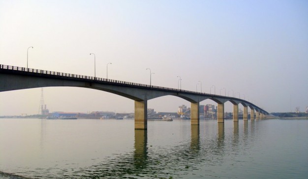
Official name of Meghna Bridge is Japan Bangladesh Friendship Bridge 1. It carries Motor vehicles and pedestrians. It is situated over the Meghna River. This bridge was designed by Cantilever bridge. The total length of the bridge is 900 meters (2,952 ft 9 inches), in width 9.2 meters (30 ft 2 inches). The longest span is 87 meters (285 ft 5 inches). It was opened for public in February 1, 1991. The coordinates is 23°36.162′N 90°36.991′E
Meghna Bridge is a road bridge in Bangladesh. It was built by assistance of Japan and officially named Japan Bangladesh Friendship Bridge 1, but it is popularly known as Meghna Bridge. According to a study conducted in 2004 by the Embassy of Japan in Bangladesh, residents living around the Meghna Bridge recognized several positive impacts after the construction of the bridge. In 2005, the bridge underwent extensive repair because the expansion joints of the bridge were damaged due to the lack of appropriate maintenance.
Architecture: Meghna Bridge is a cantilever and girder bridge. It is 930 meters (3,051 ft 2 in) in length with dual carriageway and 9.2 meters (30 ft 2 in) in width. The bridge has thirteen spans. Two among the individual spans are of 24.25 meters (79 ft 7 in) in length each, one is of 48.3 meters (158 ft 6 in) in length, nine spans are of 87 meters (285 ft 5 in) in length each and the length of the rest is 18.2 meters (59 ft 9 in). The carriage way of the bridge is 7.2 meters (23 ft 7 in). The foundations are supported on RCC caissons and piles. Piled foundation of abutments are buried. RCC caissons which are used as foundation under the piers are also buried. Both abutments and the piers of the bridge are RCC solid type. The piers of the bridge are hexagonal. Each pier is of 11 meters (36 ft 1 in) in length and 3.2 meters (10 ft 6 in) in width.
The wing walls of the bridge are of RCC and are fixed with abutments and have no weep holes. Railing type of the bridge is of R.C.C post and steel rail. The bridge has 0.80 meters (2 ft 7 in) wide sidewalk at both sides. Meghna Bridge also has infrastructure of drainage.
Economic impact: Traffic volumes across the Meghna River and of National Highway No. 1 significantly increased after the opening of the Meghna Bridge. In April 1997, an average of 10,149 vehicles of all types used the bridge in each 24 hours while March 2004 saw 9,704 vehicles per day. The reason behind this fall in traffic volume is attributed to increase in toll rate in 2002 and seasonal fluctuations. Below is a comparison of vehicles using the bridge per day in April 1997 and March 2004.
The survey conducted in 2004 by the Embassy of Japan in Bangladesh found that a majority of the users of the bridge believe that the construction of the Meghna Bridge improved the life of the people living near it and the surrounding area of the bridge has been urbanized. The people surveyed opined that the number of traffic blockage caused by bad weather has been decreased since the construction. The survey also found that 42% of the trucks using Meghna Bridge transport goods between Dhaka and Chittagong.
Array
(
[0] => Array
(
[name] => Panam Bridge
[post_id] => 11590
[post_link] => http://offroadbangladesh.com/places/panam-bridge/
[thumb_link] => http://offroadbangladesh.com/wp-content/uploads/2015/07/120-300x169.jpg
[post_content] =>
Panam area is formed as a part of the Muslim metropolis, developed on the south of the old city, and perhaps constituted as the place of residence of the early Muslim governors'. After the Mughal conquest of Sonargaon (1611), the Panam area was connected with the ruling metropolis by construction of highways and bridges. Panam still possesses three brick bridges belonging to the Mughal period: Panam Bridge, Dalalpur Bridge and Panamnagar Bridge. The existence of these bridges and the canals enclosing the site on three sides is indicative of its being a suburban area of the medieval city.
Panam Bridge a fine old bridge constructed originally over a canal on a village road from Hajiganj to Baidyer Bazar, now located a little further to the east of Habibpur on a pucca road between Companyganj and Bari Majlis in Sonargaon. It was originally known as Companyganj ka Pul (কোম্পানিগঞ্জের পুল). The Bridge measuring about 53 meter in length and 5 metre in breadth consists of three arches, the middle arch being wider and higher providing easy passage of boats underneath. The steep roadway is formed of bricks circularly arranged. The architectural feature places the bridge to belong to the Mughal period (17th century).
)
[1] => Array
(
[name] => Mirkadim Bridge
[post_id] => 8217
[post_link] => http://offroadbangladesh.com/places/mirkadim-bridge/
[thumb_link] => http://offroadbangladesh.com/wp-content/uploads/2015/05/Mirkadim-Bridge-11-300x200.jpg
[post_content] =>
Mirkadim bridge (মীরকাদিম ব্রিজ) spans the Mir Kadim canal (creek) which runs from Mir Kadim to Tangibari. It connects the village Abdullahpur and Panam area of Rampal Union Parishad under Munshigonj District. It is situated at a distance of about 5.50 km from the district headquarters. The local tradition claims it to have been built by King Ballal Sen, but the architectural features belie the local tradition. The bridge can architecturally be attributed to the Mughal period, not earlier than 17th century. The 53m long bridge consists of a central pointed arch of 4.40m span with two side arches of 2.25m span each. The central arch is 0.40m high from the water level of the creek and at present 31m wide. It is 6.15m wide with each wing measuring 16.80m in length. The central arch is flanked by an octagonal pilaster on each side. Similarly each of the side arches has a pilaster each crowned with a cupola. The plasters of the side arches rise above the spandrel of the arch but those of the central arch are shorter and so not reach the archivolt. The pier is 1.85m thick. It is reported that on either end of the bridge there were circular pillars but now these are buried under earth. It appears that there are 6 piers on each side of the bridge. The central arch is loftier and wider than the side ones and is set in a deep rectangular panel with plain plastered spandrel. Base of the arches provided with cut waters. The hump backed bridge rises to a central point from which its back gently slopes to either side. It has a 70 cm high parapet wall on either side. The surviving thickness of the bridge measures 4.34m.
It has been protected and repaired extensively by the Department of Archaeology.
)
[2] => Array
(
[name] => Bangabandhu Bridge
[post_id] => 5289
[post_link] => http://offroadbangladesh.com/places/bangabandhu-bridge/
[thumb_link] => http://offroadbangladesh.com/wp-content/uploads/2015/03/Bangabandhu_Jamuna_Bridge2-Nusrat-Kabir1-300x210.jpg
[post_content] =>
Bangabandhu Bridge, commonly called the Jamuna Multi-Purpose Bridge (Bengali: যমুনা বহুমুখী সেতু) is a bridge opened in Bangladesh in June 1998. It connects Bhuapur on the Jamuna River's east bank to Sirajganj on its west bank. It was the 11th longest bridge in the world when constructed in 1998 and currently the 6th longest bridge in South Asia. It was constructed over the Jamuna River, one of the three major rivers of Bangladesh, and fifth largest in the world in discharge volume.
The bridge established a strategic link between the eastern and western parts of Bangladesh. It generates multifarious benefits for the people and, especially, promotes inter-regional trade in the country. Apart from quick movement of goods and passenger traffic by road and rail, it facilitated transmission of electricity and natural gas, and integration of telecommunication links. The bridge is on the Asian Highway and the Trans-Asian Railway which, when fully developed, will provide uninterrupted international road and railway links from Southeast Asia through Central Asia to northwest Europe.
The Bridge over the river Jamuna is the largest bridge from the Bangladesh. It’s now the 5th longest bridge from South Asia. This bridge connects the North Bengal, connection place is Sirajganj and Bhuapur of Tangail. This bridge was open for the public during June 1998. Initially the bridge was open for all the visitors, tourists, and all pedestrians. But now this bridge is only accessible using certain kind of vehicles.
)
[3] => Array
(
[name] => Lalon Shah Bridge
[post_id] => 2975
[post_link] => http://offroadbangladesh.com/places/lalon-shah-bridge/
[thumb_link] => http://offroadbangladesh.com/wp-content/uploads/2015/02/Lalon-Shah-Bridge-by-Mahmudur-Rahman-Khan-300x225.jpg
[post_content] =>
Lalon Shah Bridge (Bengali: লালন শাহ সেতু), also known as the Paksey Bridge, is a road bridge in Bangladesh over the river Padma, situated between Ishwardi Upazila of Pabna on the east, and Bheramara Upazila of Kushtia on the west. Named after early 19th century mystic poet Lalon Shah of Chhewuriya, Kushtia District, the bridge was completed in 2004.
The bridge is 1,800 metres (5,900 ft) long and is the fourth longest road bridge of the country, after Jamuna Bridge, Meghna Bridge and Meghna-Gomti bridge. It provides important road connection to Mongla port of Khulna District in the south from Rajshahi division and Rangpur division, the northern part of Bangladesh. It is situated parallel to and south (downstream) of Hardinge Bridge.
)
)